Image:Pyrenees-Atlantiques topographic map-fr.jpg
Un article de Wikipédia, l'encyclopédie libre.
Taille de cet aperçu : 800 × 545 pixels
Image en plus haute résolution (2 350 × 1 600 pixels, taille du fichier : 1,27 Mio, type MIME : image/jpeg)
| | Ce fichier provient de Wikimedia Commons?. Les informations le concernant sont affichées ci-dessous (procédure). |
[edit] Summary
| Camera location | This and other geocoded Commons images: | (Info) |
|---|
| Description |
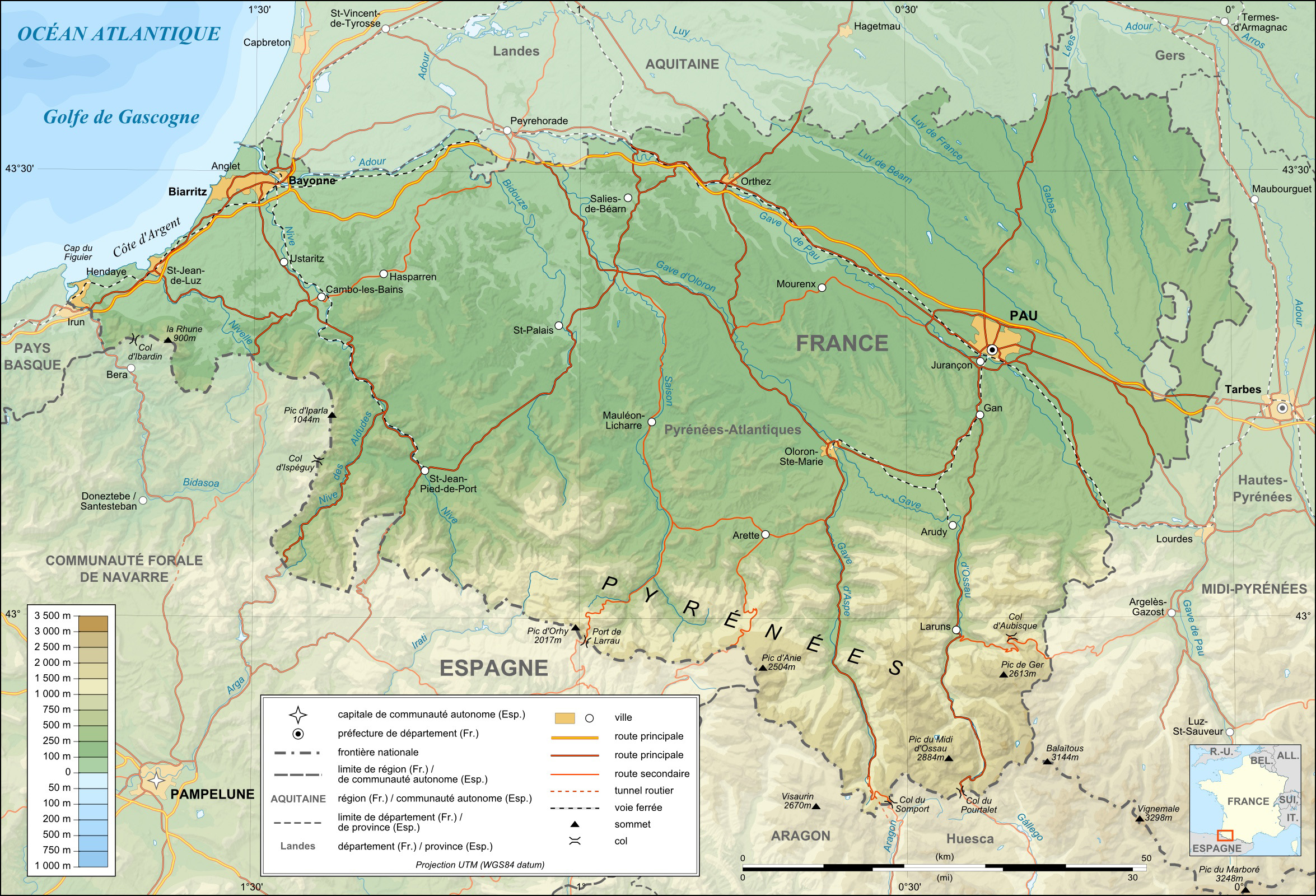
English: Topographic map in French of the department of the Pyrénées-Atlantiques
This is a lighter raster JPG format version of Image:Pyrenees-Atlantiques_topographic_map-fr.svg which should be used in the article pages, the vector graphics version purpose being for modification and / or translation. Approximate scales : * Topographic data : 1:400,000 (accuracy : about 100 m) ; * Bathymetry : 1:4 000 000 (accuracy : about 1,000 m) Français : Carte topographique en français du département des Pyrénées-Atlantiques
Ceci est une version bitmap au format JPG et de poids de fichier plus léger de Image:Pyrenees-Atlantiques_topographic_map-fr.svg qui devrait être utilisée dans les pages d'articles, la version vectorielle SVG étant destinée à faciliter les modifications et / ou traductions. Échelles approximatives : * Données topographiques : 1:400 000 (précision : environ 100 m) : * Bathymétrie : 1:4 000 000 (précision : environ 1 000 m) Approximate geographic limits of the map (15" close) : * SW corner : 42°41'N – 01°53'W * S-center latitude : 42°41'30"N * SE corner : 42°41'N – 00°07'E * NE corner : 43°41'N – 00°08'E * NW corner : 43°41'N – 01°54'W |
||
|---|---|---|---|
| Source |
English: Own work (see complete description on Image:Pyrenees-Atlantiques_topographic_map-fr.svg).
Français : Création personnelle (voir description complète sur Image:Pyrenees-Atlantiques_topographic_map-fr.svg).
|
||
| Date |
March 2008 |
||
| Author | |||
| Permission (Reusing this image) |
GFDL / Attribution and Share-Alike required |
||
| Other versions |
[edit]
|


English: This map was made or improved by the Wikigraphists of the Atelier graphique. You can propose maps or images to clean up and improve as well.
Esperanto: Ĉi tiu mapo estis kreita aŭ plibonigita de la Vikigrafistoj el la Grafika laborgrupo. Vi ankaŭ povas tie proponi mapojn aŭ bildojn plibonigendajn.
Español: Este mapa ha sido confeccionado o mejorado por los Wikígrafos del Taller gráfico. Puedes proponer la mejora de cualquier imagen a través de la página de Peticiones.
Français : Cette carte a été créée ou améliorée par les Wikigraphistes de l'Atelier graphique. Vous pouvez également y proposer des cartes ou des images à améliorer.
Türkçe: Bu harita Atelier graphique'ten Wikigraphistes'ler tarafından yapıldı veya geliştirildi. Siz de haritalar veya resimleri temizlemek veya geliştirmek için teklif edebilirsiniz.
[edit] Licensing

Historique du fichier
Cliquer sur une date et une heure pour voir le fichier tel qu’il était à ce moment-là
| Date et heure | Dimensions | Utilisateur | Commentaire | |
|---|---|---|---|---|
| actuel | 7 mars 2008 à 14:42 | 2 350×1 600 (1,27 Mio) | Sting | (Detail) |
| 7 mars 2008 à 04:55 | 2 350×1 600 (1,26 Mio) | Sting | (Forgotten locator map) | |
| 5 mars 2008 à 14:43 | 2 350×1 600 (1,26 Mio) | Sting | ({{Location|43|12|00|N|00|50|00|W|scale:1000000}} <br/> {{Information |Description={{en|Topographic map in French of the department of the Pyrénées-Atlantiques<br/>This is a lighter raster JPG format version of [[:Image:Pyr) |
Pages contenant l’image
Les pages ci-dessous contiennent cette image :
- Pyrénées-Atlantiques
- Pau
- Bayonne
- Bizanos
- Oloron-Sainte-Marie
- Orthez
- Villefranque (Pyrénées-Atlantiques)
- Pardies-Piétat
- La Rhune
- Anglet
- Billère
- Mazères-Lezons
- Nousty
- Lescar
- Poey-de-Lescar
- Saint-Jean-de-Luz
- Nay (Pyrénées-Atlantiques)
- Accous
- Saint-Pierre-d'Irube
- Lagos (Pyrénées-Atlantiques)
- Cambo-les-Bains
- Montaner
- Assat
- Utilisateur:Khardan/Modèle Commune 64
- Ostabat-Asme
- Morlaàs
- Mauléon-Licharre
- La Bastide-Clairence
- Biriatou
- Bidache
- Guiche
- Saint-Jean-Pied-de-Port
- Hasparren
- Hendaye
- Mourenx
- Navarrenx
- Sare
- Ainhoa
- Arthez-de-Béarn
- Bellocq
- Bielle (Pyrénées-Atlantiques)
- Eaux-Bonnes
- Espelette
- Garris
- L'Hôpital-Saint-Blaise
- Irissarry
- Aincille
- Ayherre
- Itxassou
- Lalonquette
- Saint-Pée-sur-Nivelle
- Gan (Pyrénées-Atlantiques)
- Sauveterre-de-Béarn
- Navailles-Angos
- Lons
- Laruns
- Ustaritz
- Sarrance
- Urdos
- Pontacq
- Monein
- Morlanne
- Lacommande
- Lacq
- Louhossoa
- Macaye
- Lescun (Pyrénées-Atlantiques)
- Briscous
- Sames
- Bidart
- Guéthary
- Aydius
- Bardos
- Asson
- Abère
- Abitain
- Ainharp
- Ance
- Arbouet-Sussaute
- Angaïs
- Arancou
- Agnos
- Arrien (Pyrénées-Atlantiques)
- Arudy
- Auterrive
- Abidos
- Abos
- Ahaxe-Alciette-Bascassan
- Ahetze
- Aïcirits-Camou-Suhast
- Ainhice-Mongelos
- Alçay-Alçabéhéty-Sunharette
- Aldudes
- Aast
- Bedous
- Alos-Sibas-Abense
- Andrein
- Amendeuix-Oneix
- Angous
- Anhaux
Voir plus de liens vers cette image.

