Image:Hurricane Katrina August 28 2005 NASA.jpg
Un article de Wikipédia, l'encyclopédie libre.
Taille de cet aperçu : 465 × 600 pixels
Image en plus haute résolution (6 200 × 8 000 pixels, taille du fichier : 9,5 Mio, type MIME : image/jpeg)
| | Ce fichier provient de Wikimedia Commons?. Les informations le concernant sont affichées ci-dessous (procédure). |
[edit] Summary
| Description |
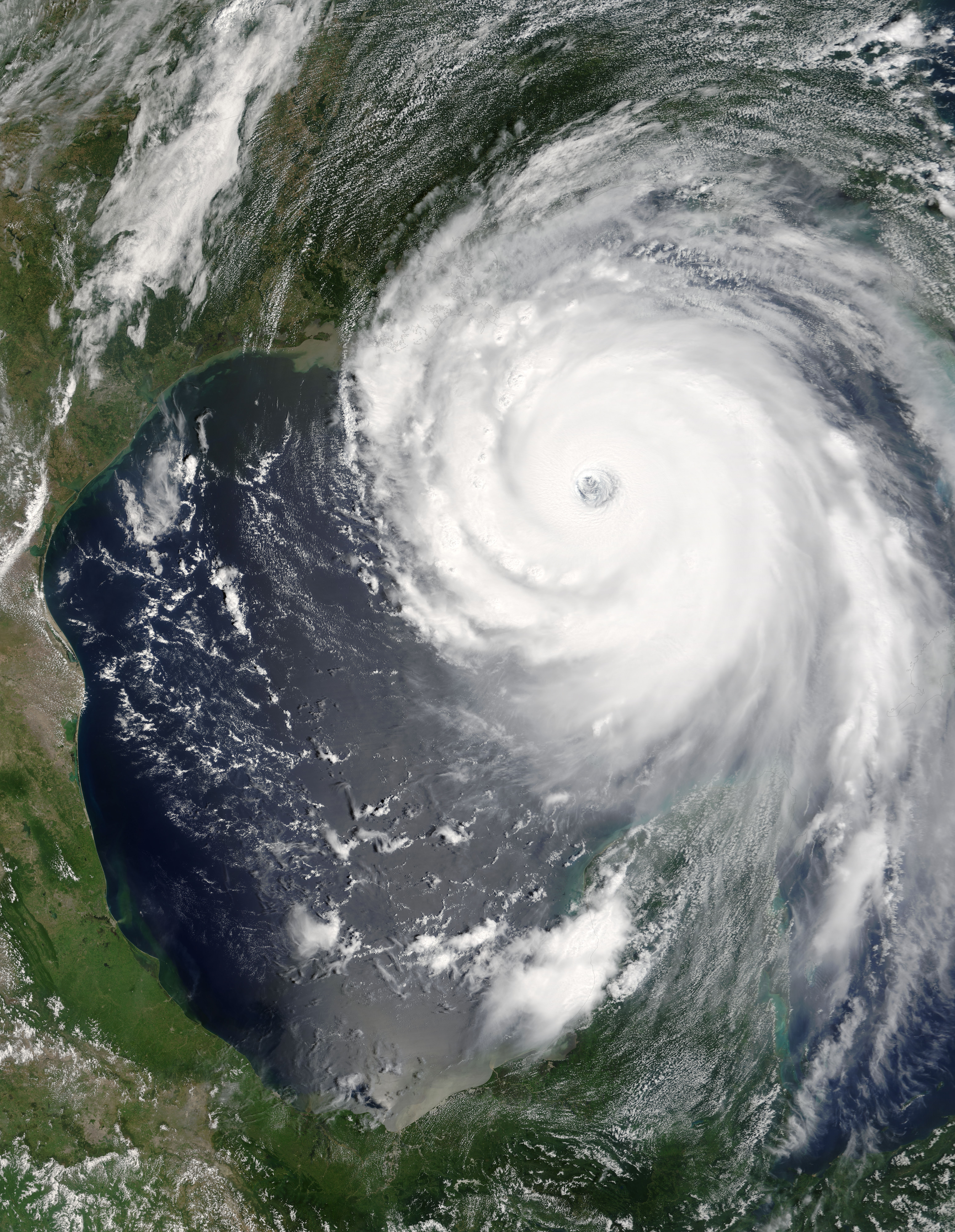
“Katrina is comparable in intensity to Hurricane Camille of 1969, only larger,” warned the National Hurricane Center on Sunday, August 28, 2005. By this time, Hurricane Katrina was set to become one of the most powerful storms to strike the United States, with winds of 257 kilometers per hour (160 miles per hour) and stronger gusts. The air pressure, another indicator of hurricane strength, at the center of this Category 5 storm measured 902 millibars, the fourth lowest air pressure on record for an Atlantic storm. The lower the air pressure, the more powerful the storm. Two hours after the National Hurricane Center issued their warning, the Moderate Resolution Imaging Spectroradiometer (MODIS) captured this image from NASA’s Terra satellite at 1:00 p.m. Eastern Daylight Savings Time. The massive storm covers much of the Gulf of Mexico, spanning from the U.S. coast to the Yucatan Peninsula. |
|||||
|---|---|---|---|---|---|---|
| Source | ||||||
| Date |
2005-08-28 |
|||||
| Author |
Jeff Schmaltz, MODIS Rapid Response Team, NASA/GSFC |
|||||
| Permission (Reusing this image) |
|

Historique du fichier
Cliquer sur une date et une heure pour voir le fichier tel qu’il était à ce moment-là
| Date et heure | Dimensions | Utilisateur | Commentaire | |
|---|---|---|---|---|
| actuel | 26 août 2006 à 18:42 | 6 200×8 000 (9,5 Mio) | Good kitty | |
| 16 septembre 2005 à 03:25 | 3 100×4 000 (3,17 Mio) | Tom | (higher res) | |
| 3 septembre 2005 à 17:07 | 775×1 000 (256 Kio) | Square87 |
Pages contenant l’image
Les pages ci-dessous contiennent cette image :
- Discussion Utilisateur:Roby
- Discussion Utilisateur:Julianedm
- Discussion Utilisateur:Grecha
- Discussion Utilisateur:Cehagenmerak
- Discussion Utilisateur:Apollofox
- Discussion Utilisateur:PhilFree
- Wikipédia:Le Bistro/octobre 2006
- Wikipédia:Le Bistro/19 octobre 2006
- Film documentaire
- Discussion Utilisateur:Flfl10
- Discuter:Une vérité qui dérange
- Discussion Utilisateur:Diablo/Politesse
- Discussion Utilisateur:Lilliputien/Renseignements généraux/RAZ
- Projet:Environnement
- Projet:Environnement/Travaux par thème
- Projet:Environnement/Une vérité qui dérange
- Discussion Utilisateur:Diablo/Sommaire
- Discussion Utilisateur:Urban2006
- Discussion Utilisateur:Bradipus/Archives5

