Image:Plan Saint-Jean-d'Acre.png
Un article de Wikipédia, l'encyclopédie libre.
Pas de plus haute résolution disponible.
Plan_Saint-Jean-d'Acre.png (320 × 326 pixels, taille du fichier : 9 Kio, type MIME : image/png)
| | Ce fichier provient de Wikimedia Commons?. Les informations le concernant sont affichées ci-dessous (procédure). |
 |
This map image should be recreated using vector graphics as an SVG file. This has several advantages; see Commons:Media for cleanup for more information. If an SVG form of this image is already available, please upload it. After uploading an SVG, replace this template with template {{Vector version available|new image name.svg}} in this image. |
|
العربية | Български | Català | Česky | Dansk | Deutsch | English | Esperanto | Español | Français | 한국어 | Italiano | Magyar | Lietuvių | Nederlands | 日本語 | Polski | Português | Română | Русский | Suomi | Svenska | Türkçe | Українська | Tiếng Việt | मराठी | 中文(繁體) | 中文(简体) | +/- |
|
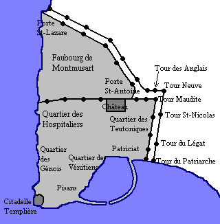
Français : Plan de fr:Saint-Jean-d'Acre au XIIe siècle
English: Map of Acre, in XIIth century

Historique du fichier
Cliquer sur une date et une heure pour voir le fichier tel qu’il était à ce moment-là
| Date et heure | Dimensions | Utilisateur | Commentaire | |
|---|---|---|---|---|
| actuel | 20 janvier 2008 à 22:54 | 320×326 (9 Kio) | Odejea | ({{fr|Plan de fr:Saint-Jean-d'Acre au XII<sup>e</sup> siècle}} {{en|Map of Acre, in XII<sup>th</sup> century}} {{User:Odejea/Licences}} Category:Maps of the Crusades ) |
Pages contenant l’image
La page ci-dessous contient cette image :

