Image:Nuclear power plants map Ukraine-fr.png
Un article de Wikipédia, l'encyclopédie libre.
Pas de plus haute résolution disponible.
Nuclear_power_plants_map_Ukraine-fr.png (634 × 324 pixels, taille du fichier : 78 Kio, type MIME : image/png)
| | Ce fichier provient de Wikimedia Commons?. Les informations le concernant sont affichées ci-dessous (procédure). |
[edit] Summary
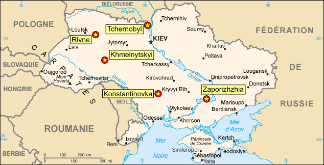
| Description |
Map of the Ukrainian nuclear power plants (in French) |
|---|---|
| Source |
Background map : Image:Ukraine_carte.png, a modified version of the CIA World Factbook map |
| Date |
September 2006 |
| Author |
Eric Gaba (Sting) |
| Permission (Reusing this image) |
Public domain |
- Sujet : Carte en français des centrales nucléaires ukrainiennes ;
- Fond de carte : Image:Ukraine_carte.png, une version modifiée de la carte du CIA World Factbook ;
- Auteur : Eric Gaba (fr:Sting) ;
- Date : Septembre 2006.
[edit] Licensing
| I, the copyright holder of this work, hereby release it into the public domain. This applies worldwide. In case this is not legally possible: Afrikaans | Alemannisch | Aragonés | العربية | Asturianu | Български | Català | Česky | Cymraeg | Dansk | Deutsch | Eʋegbe | Ελληνικά | English | Español | Esperanto | Euskara | Estremeñu | فارسی | Français | Galego | 한국어 | हिन्दी | Hrvatski | Ido | Bahasa Indonesia | Íslenska | Italiano | עברית | Kurdî / كوردی | Latina | Lietuvių | Latviešu | Magyar | Македонски | Bahasa Melayu | Nederlands | Norsk (bokmål) | Norsk (nynorsk) | 日本語 | Polski | Português | Ripoarisch | Română | Русский | Shqip | Slovenčina | Slovenščina | Српски / Srpski | Svenska | ไทย | Tagalog | Türkçe | Українська | Tiếng Việt | Walon | 中文(简体) | 中文(繁體) | zh-yue-hant | +/- |
Historique du fichier
Cliquer sur une date et une heure pour voir le fichier tel qu’il était à ce moment-là
| Date et heure | Dimensions | Utilisateur | Commentaire | |
|---|---|---|---|---|
| actuel | 4 septembre 2006 à 22:45 | 634×324 (78 Kio) | Sting | ({{Information |Description=Map of the Ukrainian nuclear power plants (in French) |Source=Background map : Image:Ukraine_carte.png, a modified version of the [https://www.cia.gov/cia/publications/factbook/index.html CIA World Factbook] map |Date=Augus) |

