Image:Nargis rain 27apr-4may2008 by TRMM fr.jpg
Un article de Wikipédia, l'encyclopédie libre.
Taille de cet aperçu : 800 × 507 pixels
Image en plus haute résolution (1 800 × 1 141 pixels, taille du fichier : 258 Kio, type MIME : image/jpeg)
| | Ce fichier provient de Wikimedia Commons?. Les informations le concernant sont affichées ci-dessous (procédure). |
[edit] Description
| Description |
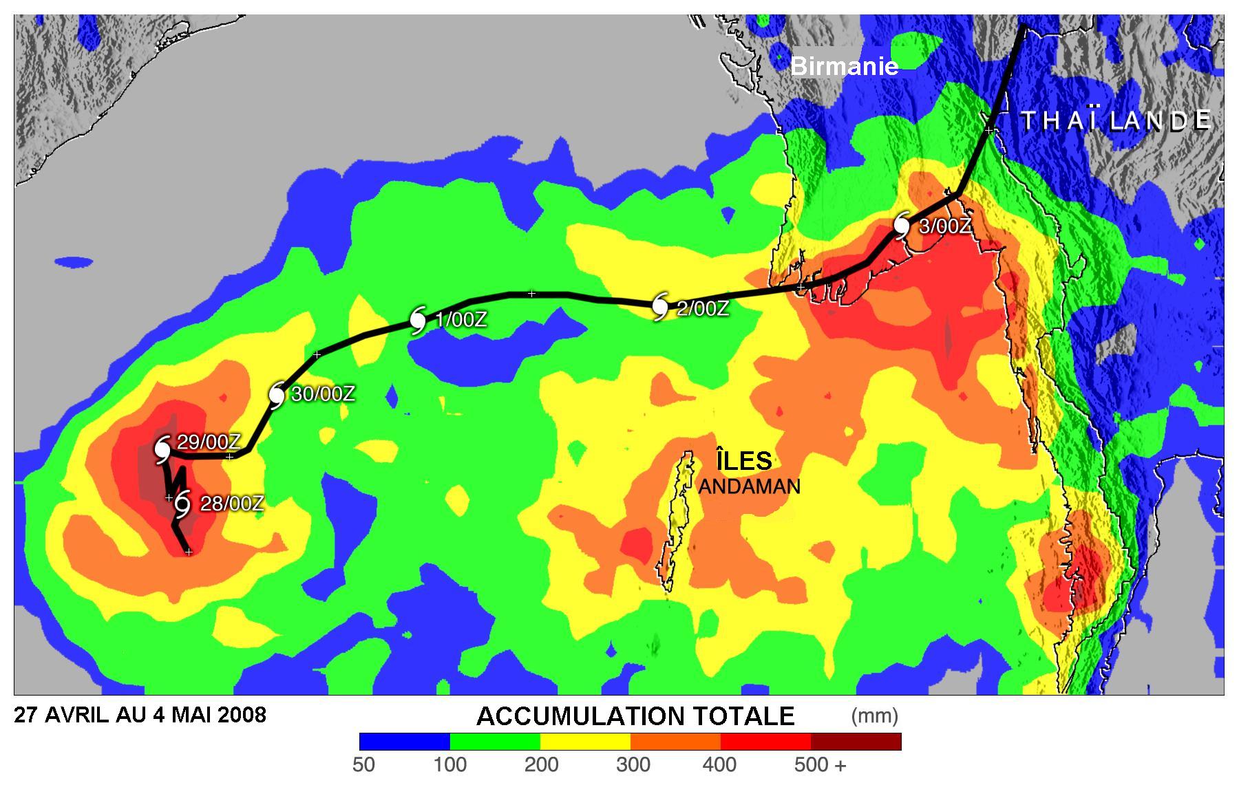
English: Estimate of rainfall with Cyclone Nargis 27 April to 4th of May 2008 according to TRMM weather satellite. Area covered of Bay of Bengal to Burma/Thailand coasts.
Français : Estimé des quantités de pluie tombées avec le Cyclone nargis entre le 27 avril et le 4 mai 2008 selon les données du satellite TRMM. Couverture des pluies sur le Golfe du Bengale, la Birmanie et la Thaïlande
|
|---|---|
| Source | |
| Date |
2008-05-04 |
| Author |
NASA, translated in French by Pierre_cb |
| Permission (Reusing this image) |
see below |
| Other versions | Image:Nargis_rain_27apr-4may2008_by_TRMM.jpg (English original version |
[edit] Licensing:
|
|
This file is in the public domain because it was created by NASA. NASA copyright policy states that "NASA material is not protected by copyright unless noted". (NASA copyright policy page or JPL Image Use Policy).
Deutsch | English | Español | Français | Nederlands | Português | Русский | 中文(简体) | 中文(繁體) | +/- |
|
 |
Warnings:
|
Historique du fichier
Cliquer sur une date et une heure pour voir le fichier tel qu’il était à ce moment-là
| Date et heure | Dimensions | Utilisateur | Commentaire | |
|---|---|---|---|---|
| actuel | 8 juin 2008 à 01:47 | 1 800×1 141 (258 Kio) | Pierre cb | (== Description == {{Information |Description={{en|1=Estimate of rainfall with Cyclone Nargis 27 April to 4th of May 2008 according to TRMM weather satellite. Area covered of Bay of Bengal to Burma/Thailand coasts.}} {{fr|1=Estimé des quantités de pluie ) |
Pages contenant l’image
La page ci-dessous contient cette image :

