Image:Map of kingdom of Arles.jpg
Un article de Wikipédia, l'encyclopédie libre.
Taille de cet aperçu : 455 × 600 pixels
Image en plus haute résolution (500 × 659 pixels, taille du fichier : 112 Kio, type MIME : image/jpeg)
| | Ce fichier provient de Wikimedia Commons?. Les informations le concernant sont affichées ci-dessous (procédure). |
[edit] Description
Note: This is not a copyright tag! Many images that use this tag are likely to be in the public domain, but many images, like for example images from WWII taken by members of the axis powers are not. Images must contain a valid copyright tag in addition to this one! For example:
or any other appropriate license tag. |
|
| This image is a copy of shepherd/roman_empire_1138_1254.jpg, a map from the map collection of the Perry-Castañeda Library (PCL) of the University of Texas at Austin. According to the FAQs it might be in the public domain, but please provide additional proof for that. | |
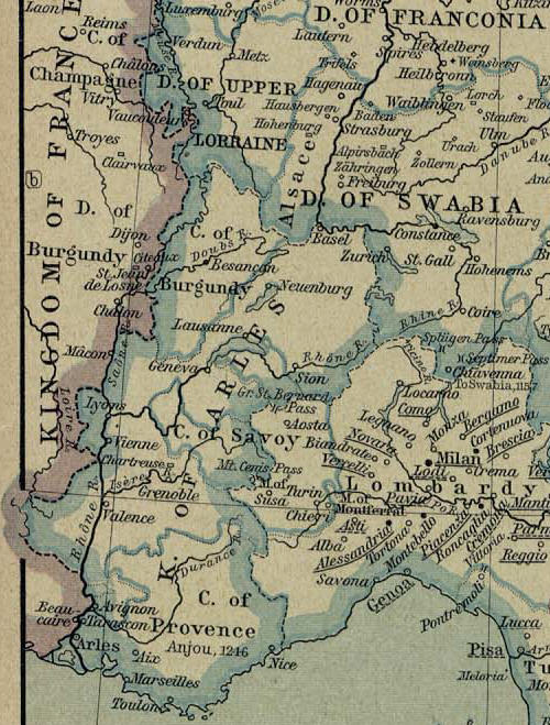
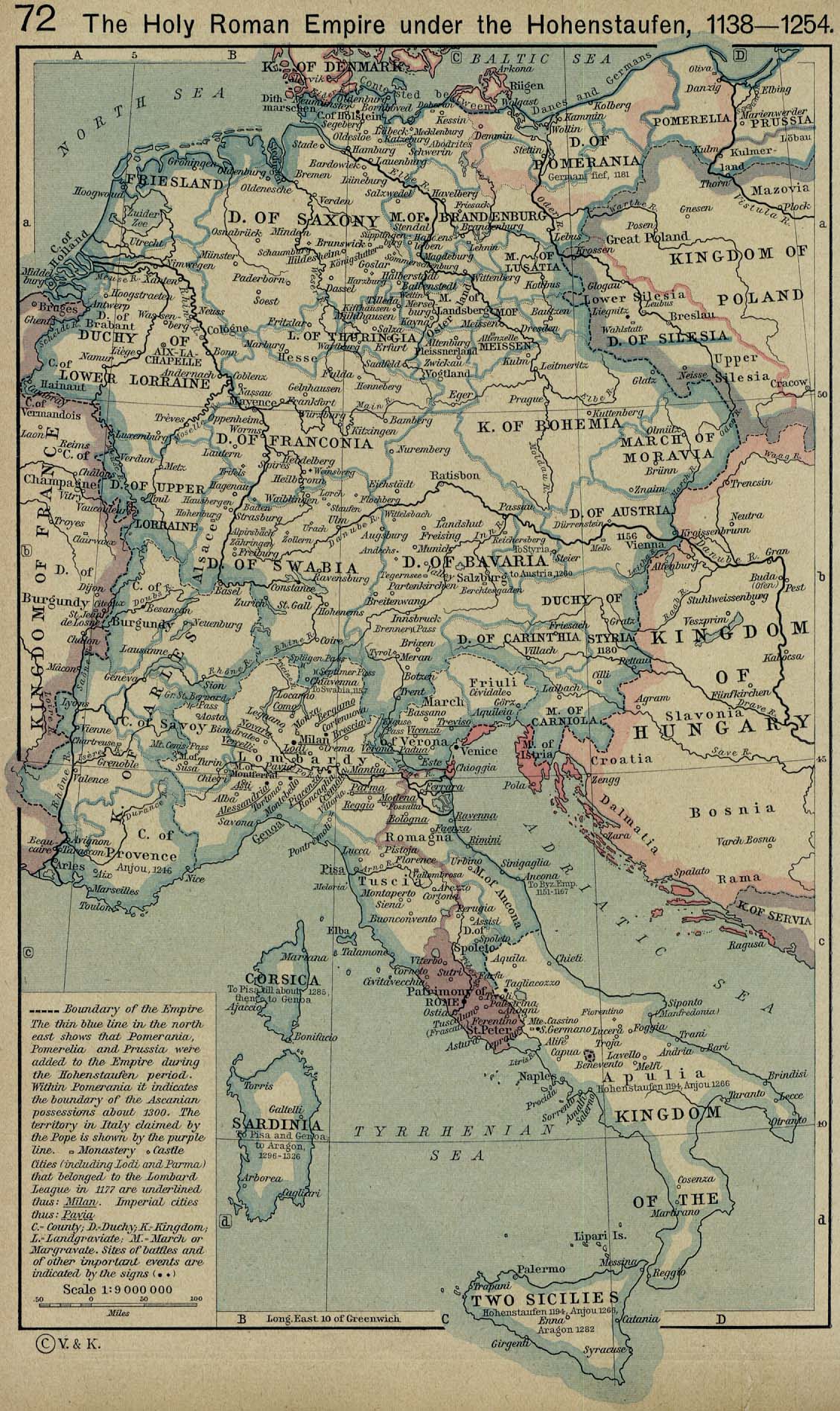
Map of Kingdom of Arles extracted from a map from the Holy Roman Empire (1138-1254)
From: Home > Finding Information > PCL Map Collection > Historical Maps of Europe - [Germany] The Holy Roman Empire under the Hohenstaufen, 1138-1254 (458K)
From The Historical Atlas by William R. Shepherd, 1926.
Initial Map modified by Poppy
[edit] Licensing
| This image (or other media file) is in the public domain because its copyright has expired. This applies to the United States, Canada, the European Union and those countries with a copyright term of life of the author plus 70 years.
العربية | Asturianu | Български | Català | Česky | Dansk | Deutsch | English | Ελληνικά | Esperanto | Español | Euskara | فارسی | Français | Gaeilge | Galego | עברית | हिन्दी | Bahasa Indonesia | Italiano | 日本語 | 한국어 | Kurdî / كوردی | Lietuvių | Magyar | Nederlands | Norsk (nynorsk) | Македонски | Bahasa Melayu | Polski | Português | Română | Русский | Slovenčina | Slovenščina | Shqip | Suomi | Sámegiella | Türkçe | 中文(简体) | 中文(繁體) | 粵語 | +/- |
Historique du fichier
Cliquer sur une date et une heure pour voir le fichier tel qu’il était à ce moment-là
| Date et heure | Dimensions | Utilisateur | Commentaire | |
|---|---|---|---|---|
| actuel | 3 janvier 2006 à 21:42 | 500×659 (112 Kio) | Poppy | (== Description == {{PD-PCL|shepherd/roman_empire_1138_1254.jpg|historical/}} Map of Kingdom of Arles extracted from a map from the Holy Roman Empire (1138-1254) From: Home > Finding Information > PCL Map Collection > Historical Maps of Europe - [German) |
Pages contenant l’image
Les pages ci-dessous contiennent cette image :

