Image:Map Praying Mantis.png
Un article de Wikipédia, l'encyclopédie libre.
Pas de plus haute résolution disponible.
Map_Praying_Mantis.png (517 × 378 pixels, taille du fichier : 152 Kio, type MIME : image/png)
| | Ce fichier provient de Wikimedia Commons?. Les informations le concernant sont affichées ci-dessous (procédure). |
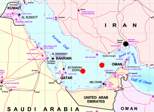
Map of Persian Gulf - marks are approxymate positions of the iranian Oilrigs Sassan (left) and Sirri (right) and the city of Bandar Abbas (black). Both rigs were destroyed while Operation Praying Mantis on April 18, 1988
The map is a part of Image:MiddleEast.png, which is marked as:
Subject: Middle East map
Source: NIMA [1]
| This work is in the public domain in the United States because it is a work of the United States Federal Government under the terms of Title 17, Chapter 1, Section 105 of the US Code. See Copyright.
Note: This only applies to works of the Federal Government and not to the work of any individual U.S. state, territory, commonwealth, county, municipality, or any other subdivision. العربية | Български | Česky | Deutsch | English | Español | Français | Magyar | Italiano | 日本語 | 한국어 | Polski | Português | 中文(繁體) | 中文(简体) | +/- |
 |
Historique du fichier
Cliquer sur une date et une heure pour voir le fichier tel qu’il était à ce moment-là
| Date et heure | Dimensions | Utilisateur | Commentaire | |
|---|---|---|---|---|
| actuel | 29 avril 2006 à 22:35 | 517×378 (152 Kio) | Schlendrian | (Map of Persian Gulf - marks are approxymate positions of the iranian Oilrigs ''Sassan'' (left) and ''Sirri'' (right) and the city of Bandar Abbas (black). Both rigs were destroyed while Operation Praying Mantis on April 18, 1988 The map is a part of [[:I) |
Pages contenant l’image
Les pages ci-dessous contiennent cette image :

