Image:Lake tana.jpg
Un article de Wikipédia, l'encyclopédie libre.
Taille de cet aperçu : 600 × 600 pixels
Image en plus haute résolution (639 × 639 pixels, taille du fichier : 150 Kio, type MIME : image/jpeg)
| | Ce fichier provient de Wikimedia Commons?. Les informations le concernant sont affichées ci-dessous (procédure). |
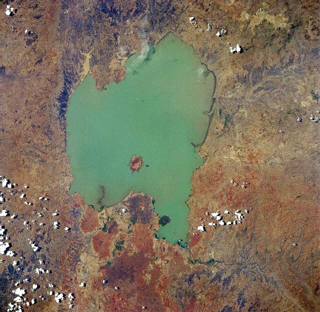
Lake Tana, Ethiopia - April 1991
[edit] image description
Considered the source of the Blue Nile River, Lake Tana is visible in this spectacular, low-oblique, west-looking photograph. Located in the central highlands of Ethiopia, Lake Tana, the country’s largest lake, covers 1400 square miles (3625 square kilometers). The lake is 47 miles (76 kilometers) long and 44 miles (71 kilometers) wide and sits at an elevation of 6000 feet (1830 meters) above sea level. Lake Tana has become sediment-filled because of many small streams flowing into it and area deforestation. At its southern end, the lake drains into the Blue Nile, which shortly thereafter [6 miles (9 kilometers)] plunges over the Tisisat Falls and turns eastward, then southeastward, into a series of rugged canyons. [1]
|
|
This file is in the public domain because it was created by NASA. NASA copyright policy states that "NASA material is not protected by copyright unless noted". (NASA copyright policy page or JPL Image Use Policy).
Deutsch | English | Español | Français | Nederlands | Português | Русский | 中文(简体) | 中文(繁體) | +/- |
|
 |
Warnings:
|
Historique du fichier
Cliquer sur une date et une heure pour voir le fichier tel qu’il était à ce moment-là
| Date et heure | Dimensions | Utilisateur | Commentaire | |
|---|---|---|---|---|
| actuel | 13 août 2005 à 03:49 | 639×639 (150 Kio) | Boticario | (Lake Tana, Ethiopia - April 1991 image description [http://eol.jsc.nasa.gov/sseop/EFS/photoinfo.pl?PHOTO=STS037-84-3 here] {{PD-USGov-NASA}} ) |
Pages contenant l’image
La page ci-dessous contient cette image :
Métadonnées
Ce fichier contient des informations supplémentaires probablement ajoutées par l’appareil photo numérique ou le numériseur qui l’a acquis. Si le fichier a été modifié depuis son état original, certains détails peuvent ne pas refléter entièrement l’image modifiée.
| Orientation | Normale |
|---|---|
| Résolution horizontale | 72 dpi |
| Résolution verticale | 72 dpi |
| Positionnement YCbCr | 1 |
| Version EXIF | 2 |
| Espace colorimétrique | sRGB |

