Image:Ekarma - Landsat 7.jpg
Un article de Wikipédia, l'encyclopédie libre.
Taille de cet aperçu : 776 × 600 pixels
Image en plus haute résolution (880 × 680 pixels, taille du fichier : 164 Kio, type MIME : image/jpeg)
| | Ce fichier provient de Wikimedia Commons?. Les informations le concernant sont affichées ci-dessous (procédure). |
(This summary was created using Commons SumItUp)
| Description |
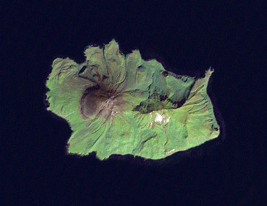
Landsat 7 image of the Kuril Island of Ekarma, 14.25 meter resolution. Based on Global Orthorectified Landsat dataset (ETM+); WRS_PATH 101, WRS_ROW 026. Generated using panchromatic band for intensity, and color from "true-color" combination of 28.5 meter resolution bands 3, 2, & 1 (as R, G, B respectively). Data combined and color curves enhanced in the Gimp. |
|---|---|
| Source |
Data from USGS GloVis server http://glovis.usgs.gov/. Landsat Orthorectified data generated through NASA's Commercial Remote Sensing Program. |
| Date |
Data acquisition: 2000-09-11. Orthorectified version produced: 2002-12-04. Image created: 2007-02-04. |
| Author |
Data: NASA. Image: Dave Pape |
| Permission (Reusing this image) |
Original data PD-NASA; any copyright that exists from my creation of this image is dedicated to the public domain (PD-SELF) |
| Other versions | Image:Ekarma.png |
| Camera location | This and other geocoded Commons images: | (Info) |
|---|
[edit] Licensing
|
|
This file is in the public domain because it was created by NASA. NASA copyright policy states that "NASA material is not protected by copyright unless noted". (NASA copyright policy page or JPL Image Use Policy).
Deutsch | English | Español | Français | Nederlands | Português | Русский | 中文(简体) | 中文(繁體) | +/- |
|
 |
Warnings:
|
| This work is based on a work in the public domain. It has been digitally enhanced and/or modified. This derivative work has been (or is hereby) released into the public domain by its author, Davepape. This applies worldwide. In some countries this may not be legally possible; if so: |
Historique du fichier
Cliquer sur une date et une heure pour voir le fichier tel qu’il était à ce moment-là
| Date et heure | Dimensions | Utilisateur | Commentaire | |
|---|---|---|---|---|
| actuel | 4 février 2007 à 21:34 | 880×680 (164 Kio) | Davepape | ({{cs|'''Ekarma''' ( japonsky: 越渇磨島, ''Ekaruma-tó''; rusky: ''Остров Зкарма'') je jeden z ostrovů v Kurilském souostroví. Ekarma se rozkládá 8,5 km západně od [[:cs:) |
Pages contenant l’image
La page ci-dessous contient cette image :

