Image:Deutschland Besatzungszonen 1945 1946.png
Un article de Wikipédia, l'encyclopédie libre.
Taille de cet aperçu : 464 × 599 pixels
Image en plus haute résolution (500 × 646 pixels, taille du fichier : 20 Kio, type MIME : image/png)
| | Ce fichier provient de Wikimedia Commons?. Les informations le concernant sont affichées ci-dessous (procédure). |
 A vector version of this image (SVG) is available. For more information about vector graphics, read about Commons transition to SVG. Български | Deutsch | English | Español | Français | Galego | עברית | Magyar | Bahasa Indonesia | Italiano | 日本語 | 한국어 | Lietuvių | Polski | Português | Русский | Српски / Srpski | Українська | 中文(简体) | 中文(繁體) | +/- |
 |
[edit] Description, source and licence
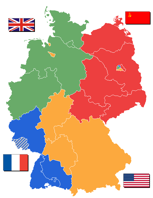
Some states of Germany ("Bundesländer" or initially "Länder") weren't created until 1946 - others Saarland, however, was removed from the French zone of occupation in 1946. State borders as shown are correct after Lippe became part of Northrhine-Westphalia January, 21st 1947.
Flags taken from Wikipedia.
Map drawn by user WikiNight
[edit] Lizenz

[edit] Image History
- 11:44, 31. Okt 2005 . . WikiNight (Diskussion) . . 500 x 646 (26694 Byte) (+Landkreis Lindau korr.)
- 13:27, 20. Sep 2005 . . WikiNight (Diskussion) . . 500 x 646 (26738 Byte) (Manche Bundesländer sind erst 1946 gebildet worden. 1946 aber auch das Saarland aus der fr.BZ rausgenommen. Bild selbst erstellt.)
Historique du fichier
Cliquer sur une date et une heure pour voir le fichier tel qu’il était à ce moment-là
| Date et heure | Dimensions | Utilisateur | Commentaire | |
|---|---|---|---|---|
| actuel | 2 septembre 2006 à 15:03 | 500×646 (20 Kio) | Wereon | (In 1945-46, US flag had 48 stars) |
| 1 janvier 2006 à 12:13 | 500×646 (26 Kio) | W-j-s | (== Beschreibung, Quelle und Lizenz == Manche Bundesländer sind erst 1946 gebildet worden. 1946 aber auch das Saarland aus der fr.BZ rausgenommen. Flaggen aus Wikipedia<br/> Karte gezeichnet von User DE:WikiNight Versionsgeschichte siehe http://de.wiki) |
Pages contenant l’image
Les pages ci-dessous contiennent cette image :

