Image:Demis-kurils-russian names.png
Un article de Wikipédia, l'encyclopédie libre.
Pas de plus haute résolution disponible.
Demis-kurils-russian_names.png (663 × 462 pixels, taille du fichier : 70 Kio, type MIME : image/png)
| | Ce fichier provient de Wikimedia Commons?. Les informations le concernant sont affichées ci-dessous (procédure). |
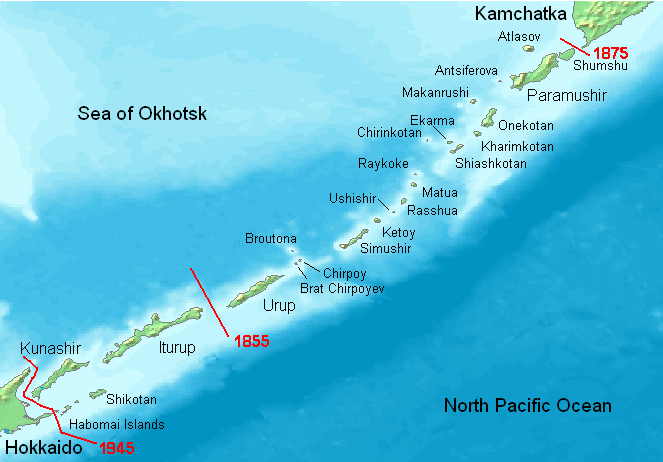
Kuril Islands overview map with current Russian names (English transliteration). Borders of Shimoda Treaty (1855) and Treaty of St. Petersburg (1875) shown in red. Currently all islands northeast of Hokkaido are administered by Russia.
Note: Ushishir actually consists of 2 islands: Ryponkicha (northeast) and Yankicha (southwest).
See also The Habomai Islands
| This image is in the public domain because came from the site http://www.demis.nl/home/pages/Gallery/examples.htm and was released by the copyright holder. Permission is granted to copy, distribute and/or modify this map since it is based on free of copyright images from: www.demis.nl. See also approval email on de.wp and its clarification. |
Historique du fichier
Cliquer sur une date et une heure pour voir le fichier tel qu’il était à ce moment-là
| Date et heure | Dimensions | Utilisateur | Commentaire | |
|---|---|---|---|---|
| actuel | 22 mai 2008 à 20:27 | 663×462 (70 Kio) | ChrisDHDR | (added the border since 1945) |
| 23 novembre 2006 à 22:00 | 663×462 (70 Kio) | Hardscarf | (Kuril Islands overviewmap with actual Russian names (English transliteration). Borders of Shimoda Treaty (1855) and Treaty of St. Petersburg (1875) shown in red. Currently all islands northwest of Hokkaido are administered by Russia. Note: Ushishir actua) |
Pages contenant l’image
Les pages ci-dessous contiennent cette image :

