Image:World map of travel & residence restrictions against people with HIV AIDS.png

Un article de Wikipédia, l'encyclopédie libre.

Ci-dessous, retrouvez page de description du fichier provenant de Commons.
Description
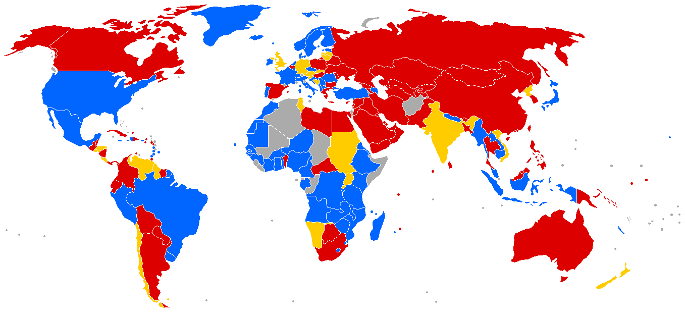
English: World map of travel and residence restrictions against people living with HIV/AIDS.

██ blue: no specific entry and regulation targetting people with HIV/AIDS.

██ orange: information is contradictory, restrictions are possible.

██ red: entry and residency restrictions confirmed.

██ gray: no information on the situation in the country.

Español: Mapa mundial acerca de las restricciones de viaje y residencia para las personas con VIH/SIDA.

██ sin restricciones específicas.

██ información contradicctoria, posibles restricciones.

██ restricciones confirmadas.

██ sin información.

Français : Carte mondiale des restrictions de voyage ou de résidence envers les personnes atteintes du HIV/sida.

██ bleu: pas de condition spécifique ou de régulation envers les personnes atteintes du HIV/sida.

██ orange: les informations sont contradictoires, des restrictions sont possibles.

██ rouge: restrictions d’entrée ou de résidence confirmées.

██ gris: pas d’information sur la situation dans le pays.

Source
  • Map based on research project sponsored by Deutsche AIDS-Hilfe e. V. and by SIDA Info Doc Switzerland.
  • Reference: http://doc.ilga.org/ilga/publications/other_publications/hiv_aids_regulations
  • For more detailed information, in English, French, German, Italian, see also: http://www.aidsnet.ch/modules.php?name=Sections&sop=listarticles&secid=13
  • Contributions are welcome to complete this map, but remember that this image is based on the ILGA reports.
  • This image is subject to updates. Avoid creating new duplicate images for them, please use the discussion page in case of errors or omissions, and upload updates on top of this image (with the same descriptive name, and the same categories). There may remain minor errors in the smallest countries, as this is the first version (I've not been able to identify exactly some islands in the Pacific).
  • Be careful when editing the image, the choice of colors was also made to be readable by people with partial or complete color-blindness (so I volontarily avoided the green/red contrast, in favor of blue/red, and all colors translate to distinctive and ordered levels of grays for printing on black-and-white printers, with minimum dithering artefacts).
    SRGB color palette: blue=#0066FF=HSV(216°,100%,100%); orange=#FFCC00=HSV(48°,100%,100%); red=#DD0000=HSV(0°,100%,86%); gray=#ABABAB=HSV(0°,0%,67%).
Date

Current version based on the 2005 report, last updated in 2006.

Author

Made by Verdy p 18:25, 11 December 2007 (UTC).

Permission
(Reusing this image)
I, the copyright holder of this work, have published or hereby publish it under the following license:
GNU head Permission is granted to copy, distribute and/or modify this document under the terms of the GNU Free Documentation license, Version 1.2 or any later version published by the Free Software Foundation; with no Invariant Sections, no Front-Cover Texts, and no Back-Cover Texts. A copy of the license is included in the section entitled "GNU Free Documentation license".

Aragonés | العربية | Asturianu | Български | বাংলা | ইমার ঠার/বিষ্ণুপ্রিয়া মণিপুরী | Brezhoneg | Bosanski | Català | Cebuano | Česky | Dansk | Deutsch | Ελληνικά | English | Esperanto | Español | Eesti | Euskara | فارسی | Suomi | Français | Gaeilge | Galego | עברית | Hrvatski | Magyar | Bahasa Indonesia | Ido | Íslenska | Italiano | 日本語 | ქართული | ភាសាខ្មែរ | 한국어 | Kurdî / كوردی | Latina | Lëtzebuergesch | Lietuvių | Bahasa Melayu | Nnapulitano | Nederlands | ‪Norsk (nynorsk)‬ | ‪Norsk (bokmål)‬ | Occitan | Polski | Português | Română | Русский | Slovenčina | Slovenščina | Shqip | Српски / Srpski | Svenska | తెలుగు | ไทย | Türkçe | Українська | اردو | Tiếng Việt | Volapük | Yorùbá | ‪中文(中国大陆)‬ | ‪中文(台灣)‬ | +/-


Historique du fichier

Cliquer sur une date et une heure pour voir le fichier tel qu’il était à ce moment-là

Date et heureDimensionsUtilisateurCommentaire
actuel22 septembre 2006 à 17:511 357×628 (29 Kio)Verdy p (World map of travel and residence restrictions against people living with HIV/AIDS. Map based on research project by Deutsche AIDS-Hilfe e. V. Reference: http://doc.ilga.org/ilga/publications/other_publications/hiv_aids_regulations )

Les pages ci-dessous contiennent cette image :