Image:STS009 Manicouagan.jpg
Un article de Wikipédia, l'encyclopédie libre.
Taille de cet aperçu : 600 × 600 pixels
Image en plus haute résolution (639 × 639 pixels, taille du fichier : 390 Kio, type MIME : image/jpeg)
| | Ce fichier provient de Wikimedia Commons?. Les informations le concernant sont affichées ci-dessous (procédure). |
[edit] Summary
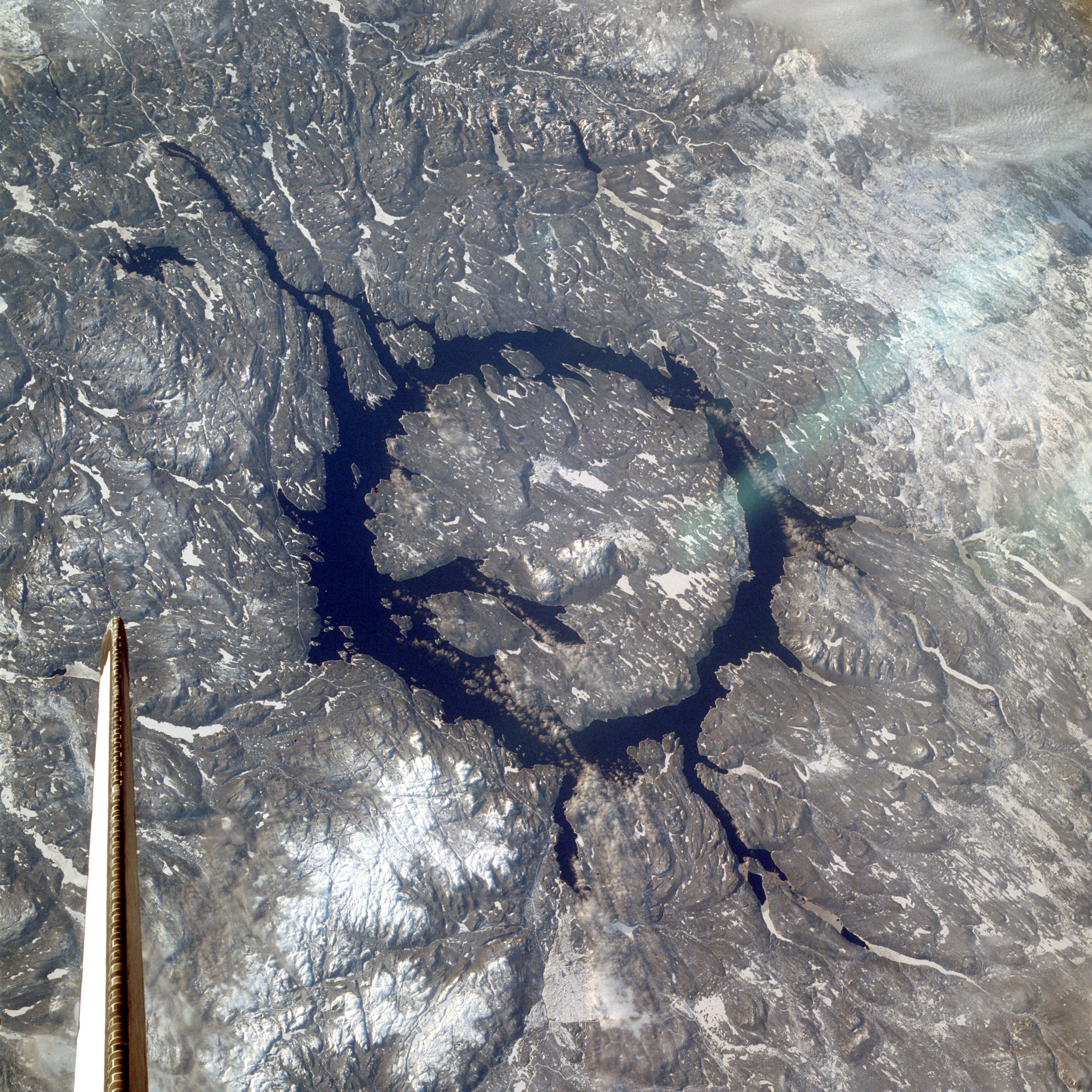
Manicouagan Reservoir with Île René-Levesseur. From w:en:Image:STS009 Manicouagan.jpg.
Information on source page:
STS009-048-3139 Manicouagan Reservoir, Canada December 1983 Located in a rugged, heavily timbered area of the Canadian Shield in Quebec Province, Manicouagan Reservoir is impressive in this low-oblique, west-looking photograph. The reservoir, a large annular lake, marks the site of an impact crater 60 miles (100 kilometers) wide. Formed almost 212 million years ago when a large meteorite hit Earth, the crater has been worn down by many advances and retreats of glaciers and other processes of erosion. The reservoir is drained at its south end by the Manicouagan River, which flows from the reservoir and empties into the Saint Lawrence River nearly 300 miles (483 kilometers) south. Image Science and Analysis Laboratory, NASA-Johnson Space Center. 18 Mar. 2005. "Earth from Space - Image Information." <http://earth.jsc.nasa.gov/sseop/efs/photoinfo.pl?PHOTO=STS009-48-3139> (10 Jul. 2005). {{PD-USGov-NASA}}
| This image or video was catalogued by one of the centers of the United States National Aeronautics and Space Administration (NASA) under Photo ID: STS009-048-3139. This tag does not indicate the copyright status of the attached work. A normal copyright tag is still required. See Commons:Licensing for more information. |
[edit] Licensing
|
|
This file is in the public domain because it was created by NASA. NASA copyright policy states that "NASA material is not protected by copyright unless noted". (NASA copyright policy page or JPL Image Use Policy).
Deutsch | English | Español | Français | Nederlands | Português | Русский | 中文(简体) | 中文(繁體) | +/- |
|
 |
Warnings:
|
Historique du fichier
Cliquer sur une date et une heure pour voir le fichier tel qu’il était à ce moment-là
| Date et heure | Dimensions | Utilisateur | Commentaire | |
|---|---|---|---|---|
| actuel | 16 octobre 2005 à 00:05 | 639×639 (390 Kio) | Mats Halldin | (Manicouagan Reservoir with Île René-Levesseur. From w:en:Image:Manicouagan-EO.JPG. '''Information on source page:''' ---- <nowiki> STS009-048-3139 Manicouagan Reservoir, Canada December) |
Pages contenant l’image
La page ci-dessous contient cette image :

