Image:Siaradwyr y Gymraeg ym Mhrif Ardaloedd Cymru.png
Un article de Wikipédia, l'encyclopédie libre.
Pas de plus haute résolution disponible.
Siaradwyr_y_Gymraeg_ym_Mhrif_Ardaloedd_Cymru.png (400 × 497 pixels, taille du fichier : 17 Kio, type MIME : image/png)
| | Ce fichier provient de Wikimedia Commons?. Les informations le concernant sont affichées ci-dessous (procédure). |
[edit] Summary
 |
This map image should be recreated using vector graphics as an SVG file. This has several advantages; see Commons:Media for cleanup for more information. If an SVG form of this image is already available, please upload it. After uploading an SVG, replace this template with template {{Vector version available|new image name.svg}} in this image. |
|
العربية | Български | Català | Česky | Dansk | Deutsch | English | Esperanto | Español | Français | 한국어 | Italiano | Magyar | Lietuvių | Nederlands | 日本語 | Polski | Português | Română | Русский | Suomi | Svenska | Türkçe | Українська | Tiếng Việt | मराठी | 中文(繁體) | 中文(简体) | +/- |
|
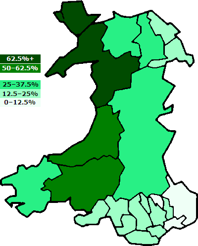
Brezhoneg : Dregantad ar gembraegerien e pastelloù-bro Kembre.
English: Percentages of Welsh speakers in the w:principal areas of Wales. Based on the GFDL Image:WalesNumbered.png. (Notice that no principal area falls within the 37,5-50% range!) QuartierLatin1968 02:30, 6 September 2005 (UTC)
Français : Pourcentages de cambrophones par arrondissement principal du pays de Galles.
Cymraeg: Cyfran y Cymry Cymraeg ym mhrif ardaloedd Cymru.
Русский: Процент владеющих валлийским языком в разных графствах Уэльса.
Deutsch: Prozentuale Verteilung der Kymrischsprecher (Walisischsprecher) in Wales. (NB: Kein County fällt in den 37,5-50%-Bereich!)
[edit] Licensing

Historique du fichier
Cliquer sur une date et une heure pour voir le fichier tel qu’il était à ce moment-là
| Date et heure | Dimensions | Utilisateur | Commentaire | |
|---|---|---|---|---|
| actuel | 6 septembre 2005 à 04:30 | 400×497 (17 Kio) | QuartierLatin1968 | (Percentages of Welsh speakers in the w:principal areas of Wales. Based on the GFDL en:Image:WalesNumbered.PNG. (Notice that ''no'' principal area falls within the 37,5-50% range!) ~~~~ Category:Maps of Wales Category:Welsh language) |
Pages contenant l’image
La page ci-dessous contient cette image :

