Image:Narita International Airport landsat.jpg
Un article de Wikipédia, l'encyclopédie libre.
Pas de plus haute résolution disponible.
Narita_International_Airport_landsat.jpg (240 × 450 pixels, taille du fichier : 65 Kio, type MIME : image/jpeg)
| | Ce fichier provient de Wikimedia Commons?. Les informations le concernant sont affichées ci-dessous (procédure). |
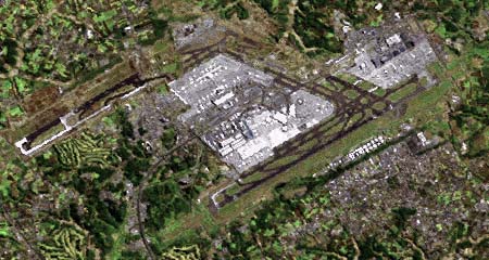
成田国際空港ラッドサット画像(2001年)。画像の上半分には建設中の暫定平行滑走路(2002年に供用開始)も見える。
Narita International Airport, Landsat photo (2001). The runway completed in 2002 is visible in the upper half of the photo.
 |
The copyright holder of this file allows anyone to use it for any purpose, so long as it is marked as "National Land Image Information (Color Aerial Photograph), Ministry of Land, Infrastructure and Transport."
このファイルの著作権保有者は誰に対しても、以下の条件を守る限り自由に利用することを許可しています。条件:「国土画像情報(カラー空中写真)国土交通省」が出典であると明記する。 |
|
This image is copyrighted by the Ministry of Land, Infrastructure and Transport of Japan. For terms of use, see MLIT Web Mapping System (in Japanese) and Message from MLIT (in Japanese). この画像は国土交通省によって著作権が保持されたままになっています。利用条件については国土交通省ウェブマッピングシステムをご覧になるか、国土交通省からのメッセージをご覧ください。 Copyright © National Land Image Information (Color Aerial Photograph), Ministry of Land, Infrastructure and Transport |
Historique du fichier
Cliquer sur une date et une heure pour voir le fichier tel qu’il était à ce moment-là
| Date et heure | Dimensions | Utilisateur | Commentaire | |
|---|---|---|---|---|
| actuel | 26 juillet 2005 à 09:45 | 240×450 (65 Kio) | Shizhao | (成田国際空港ラッドサット画像(2001年)。画像の上半分には建設中の暫定平行滑走路(2002年に供用開始)も見える。{{landsat}} ja:画像:Narita International Airport landsat.jpg (削除) (最新版) 2005�) |
Pages contenant l’image
La page ci-dessous contient cette image :
Métadonnées
Ce fichier contient des informations supplémentaires probablement ajoutées par l’appareil photo numérique ou le numériseur qui l’a acquis. Si le fichier a été modifié depuis son état original, certains détails peuvent ne pas refléter entièrement l’image modifiée.
| Orientation | Normale |
|---|---|
| Résolution horizontale | 72 dpi |
| Résolution verticale | 72 dpi |
| Logiciel utilisé | Adobe Photoshop CS Windows |
| Date de modification | 29 mai 2005 à 23:00 |
| Espace colorimétrique | sRGB |

