Image:Kansas 2003 tornado radar.gif
Un article de Wikipédia, l'encyclopédie libre.
Pas de plus haute résolution disponible.
Kansas_2003_tornado_radar.gif (773 × 462 pixels, taille du fichier : 903 Kio, type MIME : image/gif)
| | Ce fichier provient de Wikimedia Commons?. Les informations le concernant sont affichées ci-dessous (procédure). |
| Description |
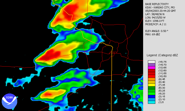
The development and dispersing of a tornado to the northwest of the NWS NEXRAD radar in Kansas City on 2003-05-04. The imagery shows the base reflectivity captured on radar. Created using NCDC JAVA NEXRAD tool. |
|||||
|---|---|---|---|---|---|---|
| Source |
Source data from NCDC NEXRAD database: http://www.ncdc.noaa.gov/nexradinv/. |
|||||
| Date |
2003-05-04 |
|||||
| Author |
Data from National Climatic Data Center, file created by Nilfanion |
|||||
| Permission (Reusing this image) |
|
Historique du fichier
Cliquer sur une date et une heure pour voir le fichier tel qu’il était à ce moment-là
| Date et heure | Dimensions | Utilisateur | Commentaire | |
|---|---|---|---|---|
| actuel | 30 août 2006 à 16:32 | 773×462 (903 Kio) | Nilfanion | ({{Information |Description=The development and dispersing of a tornado to the northwest of the NWS NEXRAD radar in Kansas City on 2003-05-04. The imagery shows the base reflectivity captured on radar. Created using NCDC [ http://www.ncdc.noaa.gov/oa/r) |
Pages contenant l’image
La page ci-dessous contient cette image :

