Image:Whitehall sketch map.png
Un article de Wikipédia, l'encyclopédie libre.
Pas de plus haute résolution disponible.
Whitehall_sketch_map.png (250 × 340 pixels, taille du fichier : 17 Kio, type MIME : image/png)
| | Ce fichier provient de Wikimedia Commons?. Les informations le concernant sont affichées ci-dessous (procédure). |
[edit] Summary
| Description |
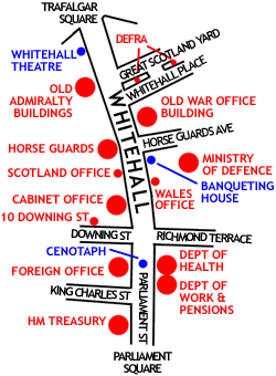
Sketch map of Whitehall, London, showing the position of the major UK Government buildings there |
|---|---|
| Source |
self-made |
| Date |
30 October 2005 |
| Author | |
| Permission (Reusing this image) |
see below |
[edit] Licensing

Historique du fichier
Cliquer sur une date et une heure pour voir le fichier tel qu’il était à ce moment-là
| Date et heure | Dimensions | Utilisateur | Commentaire | |
|---|---|---|---|---|
| actuel | 23 février 2006 à 07:49 | 250×340 (17 Kio) | JaT | (== Summary == Outline map of Whitehall, London, showing the position of the major UK Government buildings there Image by ChrisO == Licensing == {{GFDL-self}} From en:wiki Category:London) |
Pages contenant l’image
La page ci-dessous contient cette image :

