Image:Vallard map rotated.jpg
Un article de Wikipédia, l'encyclopédie libre.
Pas de plus haute résolution disponible.
Vallard_map_rotated.jpg (795 × 599 pixels, taille du fichier : 149 Kio, type MIME : image/jpeg)
| | Ce fichier provient de Wikimedia Commons?. Les informations le concernant sont affichées ci-dessous (procédure). |

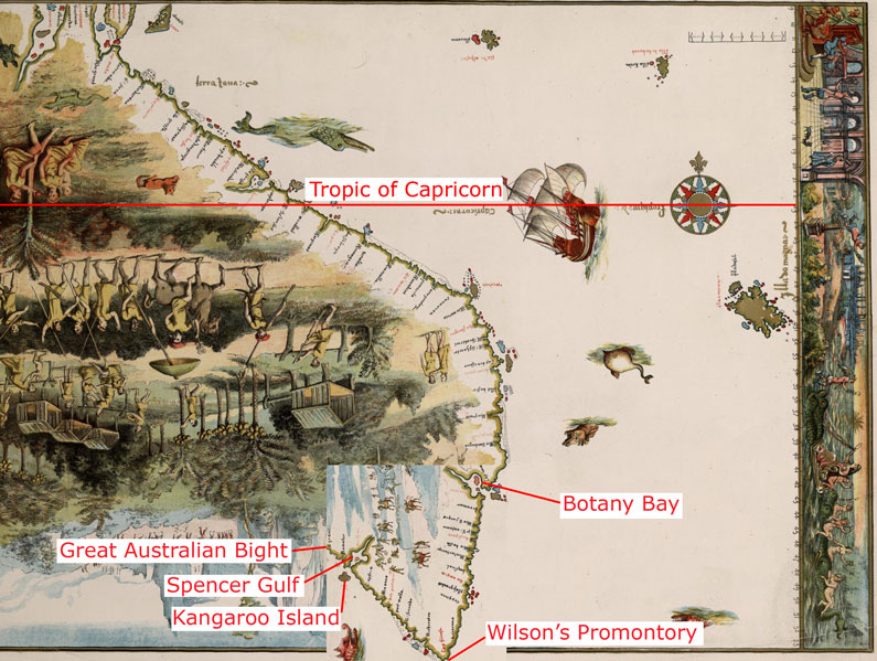
The 1542 Vallard map, with part of the bottom area rotated at 90 degrees, in the same way as described as done by journalist Peter Trickett [1] The image labelled with the claimed modern day locations shown on the map.
| This image (or other media file) is in the public domain because its copyright has expired. This applies to the United States, Canada, the European Union and those countries with a copyright term of life of the author plus 70 years.
العربية | Asturianu | Български | Català | Česky | Dansk | Deutsch | English | Ελληνικά | Esperanto | Español | Euskara | فارسی | Français | Gaeilge | Galego | עברית | हिन्दी | Bahasa Indonesia | Italiano | 日本語 | 한국어 | Kurdî / كوردی | Lietuvių | Magyar | Nederlands | Norsk (nynorsk) | Македонски | Bahasa Melayu | Polski | Português | Română | Русский | Slovenčina | Slovenščina | Shqip | Suomi | Sámegiella | Türkçe | 中文(简体) | 中文(繁體) | 粵語 | +/- |
Historique du fichier
Cliquer sur une date et une heure pour voir le fichier tel qu’il était à ce moment-là
| Date et heure | Dimensions | Utilisateur | Commentaire | |
|---|---|---|---|---|
| actuel | 23 mars 2007 à 10:59 | 795×599 (149 Kio) | Roke | (The 1542 Vallard map, with part of the bottom area rotated at 90 degrees, in the same way as described as done by journalist Peter Trickett [http://www.smh.com.au/news/national/rotated-map-puts-a-twist-in-the-foundation-) |
Pages contenant l’image
La page ci-dessous contient cette image :

