Image:TitanicRoute.png
Un article de Wikipédia, l'encyclopédie libre.
Pas de plus haute résolution disponible.
TitanicRoute.png (800 × 332 pixels, taille du fichier : 93 Kio, type MIME : image/png)
| | Ce fichier provient de Wikimedia Commons?. Les informations le concernant sont affichées ci-dessous (procédure). |
[edit] Description
| Description |
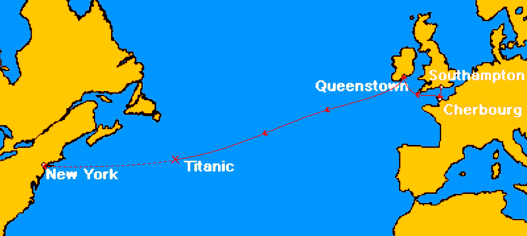
Map marks the route of Titanic during her maiden voyage, the ports on that route, and approximate location of where she sank. The remaining portion of her uncompleted route is shown dashed. |
||
|---|---|---|---|
| Source |
This image was created by en:User:MechBrowman using http://www.aquarius.geomar.de/omc/ and Paint Shop Pro and edited by en:User:Gary Joseph 23:05, 8 October 2006 (UTC) using Corel Draw 12. |
||
| Date | |||
| Author | |||
| Permission (Reusing this image) |
|
||
| Other versions |
|
 |
This map image should be recreated using vector graphics as an SVG file. This has several advantages; see Commons:Media for cleanup for more information. If an SVG form of this image is already available, please upload it. After uploading an SVG, replace this template with template {{Vector version available|new image name.svg}} in this image. |
|
العربية | Български | Català | Česky | Dansk | Deutsch | English | Esperanto | Español | Français | 한국어 | Italiano | Magyar | Lietuvių | Nederlands | 日本語 | Polski | Português | Română | Русский | Suomi | Svenska | Türkçe | Українська | Tiếng Việt | मराठी | 中文(繁體) | 中文(简体) | +/- |
|
Historique du fichier
Cliquer sur une date et une heure pour voir le fichier tel qu’il était à ce moment-là
| Date et heure | Dimensions | Utilisateur | Commentaire | |
|---|---|---|---|---|
| actuel | 22 février 2007 à 17:03 | 800×332 (93 Kio) | Nimbus08 | ({{Information |Description=Route du RMS Titanic en 1912 |Source=http://en.wikipedia.org/wiki/Image:TitanicRoute.png |Date=08/10/06 |Author=Gary Joseph |Permission= |other_versions= }}) |
Pages contenant l’image
La page ci-dessous contient cette image :

