Image:Titan globe.jpg
Un article de Wikipédia, l'encyclopédie libre.

Taille de cet aperçu : 600 × 600 pixels
Image en plus haute résolution (2 575 × 2 575 pixels, taille du fichier : 525 Kio, type MIME : image/jpeg)
| | Ce fichier provient de Wikimedia Commons?. Les informations le concernant sont affichées ci-dessous (procédure). |
| Description |
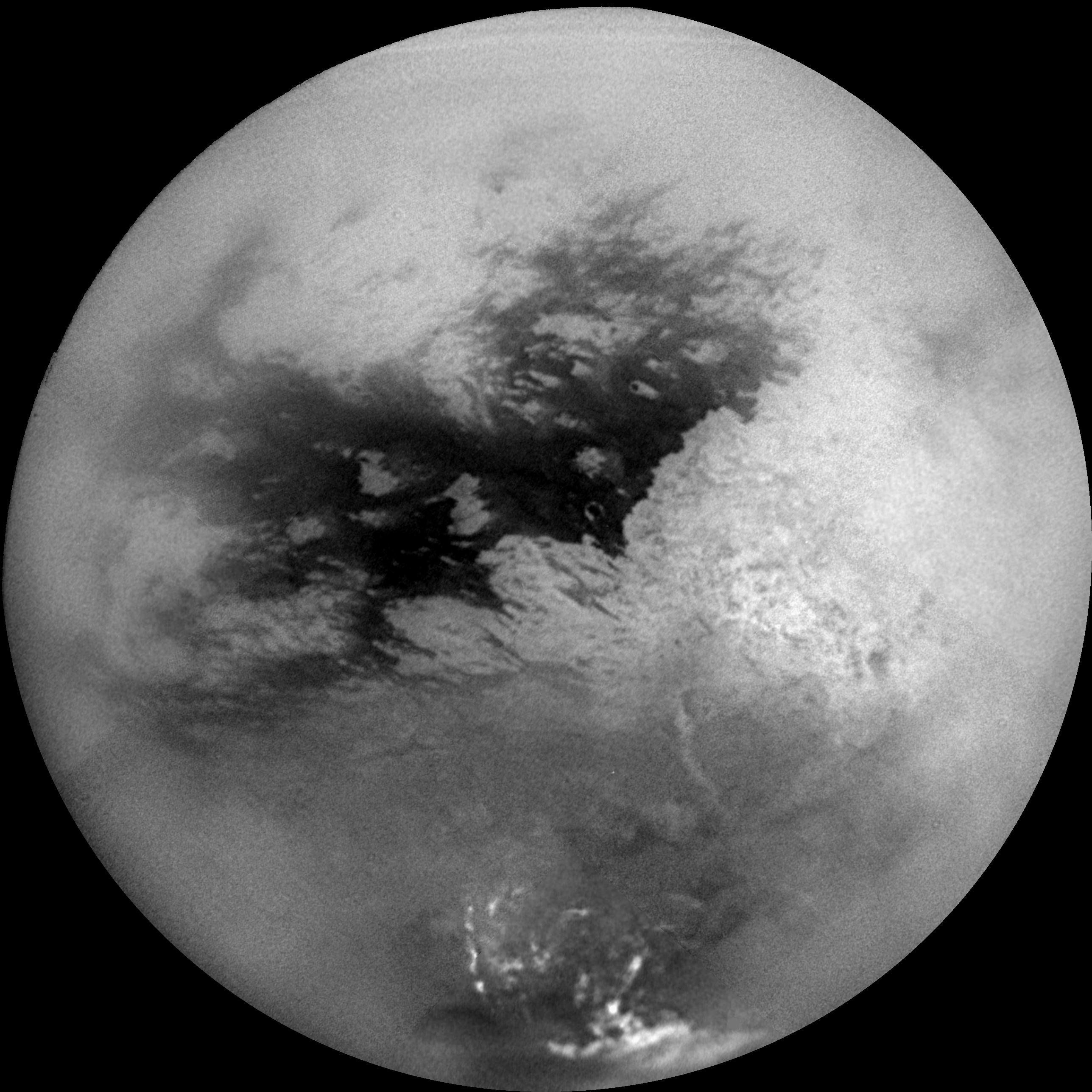
English: A mosaic of nine processed images acquired during Cassini's first very close flyby of Saturn's moon Titan on Oct. 26, 2004, constitutes the most detailed full-disc view of the mysterious moon. The view is centered on 15 degrees South latitude, and 156 degrees West longitude. Brightness variations across the surface and bright clouds near the south pole are easily seen. The images that comprise the mosaic have been processed to reduce the effects of the atmosphere and to sharpen surface features. The mosaic has been trimmed to show only the illuminated surface and not the atmosphere above the edge of the moon. The Sun was behind Cassini so nearly the full disc is illuminated. Pixels scales of the composite images vary from 2 to 4 kilometers per pixel (1.2 to 2.5 miles per pixel). Surface features are best seen near the center of the disc, where the spacecraft is looking directly downwards; the contrast becomes progressively lower and surface features become fuzzier towards the outside, where the spacecraft is peering through haze, a circumstance that washes out surface features. The brighter region on the right side and equatorial region is named Xanadu Regio. Scientists are actively debating what processes may have created the bizarre surface brightness patterns seen here. The images hint at a young surface with, no obvious craters. However, the exact nature of that activity, whether tectonic, wind-blown, fluvial, marine, or volcanic is still to be determined. The images comprising this mosaic were acquired from distances ranging from 650,000 kilometers (400,000 miles) to 300,000 kilometers (200,000 miles).
Français : Titan : une des lunes de Saturne vue par la mission Cassini, le 26 octobre 2004. Cettte mosaïque de neuf images montre des variations d'éclat de la surface de Titan, et des nuages lumineux près du pôle sud. Elle est centrée sur 15° Sud, 156° Ouest. Les images ont été traitées afin d'améliorer la netteté des détails de la surface. Malgré cela, plus on s'approche du limbe, plus l'image est floue car la ligne de visée traverse davantage d'atmosphère. La région la plus lumineuse du côté droit et la région équatoriale portent le nom de Xanadu Regio. La surface semble jeune et il n'y a pas de cratère visible. Les images ont été prises d'une distance variant entre 650 000 et 300 000 km.
|
|---|---|
| Source |
NASA planetary photojournal |
| Date |
2004-10-26 (image taken on that day) |
| Author |
NASA/JPL/Space Science Institute |
| Permission (Reusing this image) |
Copyright information from http://www.jpl.nasa.gov/images/policy/index.cfm - Unless otherwise noted, images and video on JPL public web sites (public sites ending with a jpl.nasa.gov address) may be used for any purpose without prior permission [...] |
|
|
This file is in the public domain because it was created by NASA. NASA copyright policy states that "NASA material is not protected by copyright unless noted". (NASA copyright policy page or JPL Image Use Policy).
Deutsch | English | Español | Français | Nederlands | Português | Русский | 中文(简体) | 中文(繁體) | +/- |
|
 |
Warnings:
|
Historique du fichier
Cliquer sur une date et une heure pour voir le fichier tel qu’il était à ce moment-là
| Date et heure | Dimensions | Utilisateur | Commentaire | |
|---|---|---|---|---|
| actuel | 8 avril 2005 à 17:59 | 2 575×2 575 (525 Kio) | Arnomane | (higher resolution) |
| 17 janvier 2005 à 03:07 | 1 000×1 000 (100 Kio) | Kristaga | (From en.wiki (ESA image)) |
Pages contenant l’image
Les pages ci-dessous contiennent cette image :

