Image:Tectonic plate boundaries2.png
Un article de Wikipédia, l'encyclopédie libre.
Pas de plus haute résolution disponible.
Tectonic_plate_boundaries2.png (735 × 417 pixels, taille du fichier : 181 Kio, type MIME : image/png)
| | Ce fichier provient de Wikimedia Commons?. Les informations le concernant sont affichées ci-dessous (procédure). |
| Description |
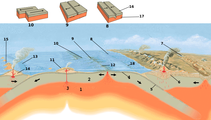
Tectonics plates map internationalized. 1-Asthenosphere; 2-Lithosphere; 3-Hot spot; 4-Oceanic crust; 5-Subducting plate; 6-Continental crust; 7-Continental rift zone (young plate boundary); 8-Convergent boundary plate; 9-Divergent boundary plate; 10-Transform plate boundary; 11-Shield volcano; 12-Oceanic spreading ridge; 13-Convergent plate boundary; 14-Strato volcano; 15-Island arc; 16-Plate 17-Asthenosphere; 18-Trench |
|---|---|
| Source |
http://commons.wikimedia.org/wiki/Image:Tectonic_plate_boundaries.png |
| Date | |
| Author |
USGS/USGov, modified by Eurico Zimbres |
| Permission (Reusing this image) |
Free for all use |
[edit] Licensing
| This work is in the public domain in the United States because it is a work of the United States Federal Government under the terms of Title 17, Chapter 1, Section 105 of the US Code. See Copyright.
Note: This only applies to works of the Federal Government and not to the work of any individual U.S. state, territory, commonwealth, county, municipality, or any other subdivision. العربية | Български | Česky | Deutsch | English | Español | Français | Magyar | Italiano | 日本語 | 한국어 | Polski | Português | 中文(繁體) | 中文(简体) | +/- |
 |
Historique du fichier
Cliquer sur une date et une heure pour voir le fichier tel qu’il était à ce moment-là
| Date et heure | Dimensions | Utilisateur | Commentaire | |
|---|---|---|---|---|
| actuel | 22 mai 2006 à 13:10 | 735×417 (181 Kio) | Zimbres | |
| 22 mai 2006 à 13:00 | 735×417 (166 Kio) | Zimbres | ({{Information| |Description= Tectonics plates map internationalized. 1-Astenosphere; 2-Litosphere; 3-Hot spot; 4-Oceanic crust; 5-Subducting plate; 6-Continental crust; 7-Continental rift zone (young plate boundary); 8-Convergent boundary plate; 9-Diverge) |
Pages contenant l’image
La page ci-dessous contient cette image :

