Image:SovietUnionUkraine.png
Un article de Wikipédia, l'encyclopédie libre.
Pas de plus haute résolution disponible.
SovietUnionUkraine.png (250 × 171 pixels, taille du fichier : 20 Kio, type MIME : image/png)
| | Ce fichier provient de Wikimedia Commons?. Les informations le concernant sont affichées ci-dessous (procédure). |
 |
This map image should be recreated using vector graphics as an SVG file. This has several advantages; see Commons:Media for cleanup for more information. If an SVG form of this image is already available, please upload it. After uploading an SVG, replace this template with template {{Vector version available|new image name.svg}} in this image. |
|
العربية | Български | Català | Česky | Dansk | Deutsch | English | Esperanto | Español | Français | 한국어 | Italiano | Magyar | Lietuvių | Nederlands | 日本語 | Polski | Português | Română | Русский | Suomi | Svenska | Türkçe | Українська | Tiếng Việt | मराठी | 中文(繁體) | 中文(简体) | +/- |
|
[edit] Summary
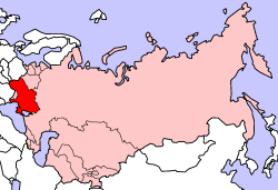
Location of ukrainian SSR in the Soviet Union.
Originally uploaded to English Wikipedia.
History of uploads:
- 16:06, 19 September 2004 . . Aris Katsaris . . 250x171 (20288 bytes) (correcting island)
- 19:42, 28 February 2004 . . Morwen . . 250x171 (27258 bytes) ({{msg:GFDL}})
- 19:42, 28 February 2004 . . Morwen . . 250x171 (27258 bytes) ({{msg:GFDL}})
[edit] Licensing
 |
Permission is granted to copy, distribute and/or modify this document under the terms of the GNU Free Documentation License, Version 1.2 or any later version published by the Free Software Foundation; with no Invariant Sections, no Front-Cover Texts, and no Back-Cover Texts. Subject to disclaimers. Asturianu | Български | Català | Deutsch | English | Español | Français | Gaeilge | Italiano | 한국어 | 日本語 | Polski | Português | Română | Türkçe | +/- |
Historique du fichier
Cliquer sur une date et une heure pour voir le fichier tel qu’il était à ce moment-là
| Date et heure | Dimensions | Utilisateur | Commentaire | |
|---|---|---|---|---|
| actuel | 2 octobre 2005 à 17:59 | 250×171 (20 Kio) | Marcos Felipe | (Location of ukrainian SSR in the Soviet Union. Taken from en: wikipedia Category:Political_divisions_of_the_Soviet_Union) |
Pages contenant l’image
La page ci-dessous contient cette image :

