Image:SI-metrication-world.png
Un article de Wikipédia, l'encyclopédie libre.
Taille de cet aperçu : 800 × 413 pixels
Image en plus haute résolution (1 357 × 700 pixels, taille du fichier : 454 Kio, type MIME : image/png)
| | Ce fichier provient de Wikimedia Commons?. Les informations le concernant sont affichées ci-dessous (procédure). |
[edit] Summary
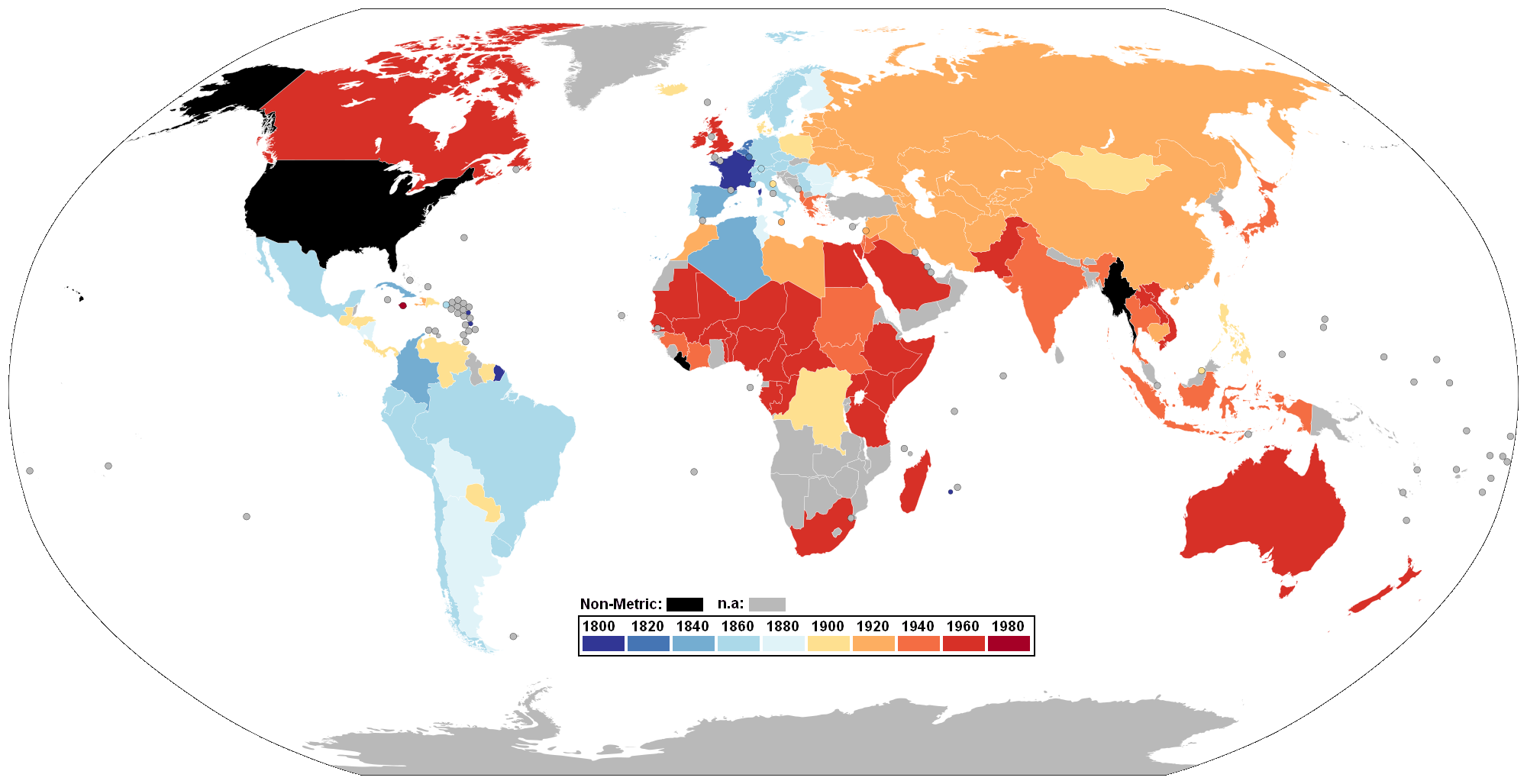
World Map showing Metrication, colour-coded by year of conversion. Using data from USMA (U.S. Metric Association) here.
(Note regarding the United Kingdom and the United States: Data indicates UK was metric in the 1960s - they made a decision to go metric in the 1960s and made a legal commitment to do so in 1973 as part of its conditions for membership in the EEC (now the EU), but then did little about the decision. The UK now uses a combination of metric and imperial however, and it is illegal to sell products weighed only in imperial measurements but imperial may be shown alongside metric weights; imperial measurements have not been taught in schools since the 1970s either. The European Union no longer requires the United Kingdom to convert completely to metric. This is similar to the situation occurring in the US, where metric is the 'official' system for lengths and weights, though its metrication process has been very slow due to public pressure and lack of funding.)
Image created and contributed to the public domain by Seabhcán
[edit] Licensing
 |
Permission is granted to copy, distribute and/or modify this document under the terms of the GNU Free Documentation License, Version 1.2 or any later version published by the Free Software Foundation; with no Invariant Sections, no Front-Cover Texts, and no Back-Cover Texts. Subject to disclaimers. Asturianu | Български | Català | Deutsch | English | Español | Français | Gaeilge | Italiano | 한국어 | 日本語 | Polski | Português | Română | Türkçe | +/- |
 |
This map image should be recreated using vector graphics as an SVG file. This has several advantages; see Commons:Media for cleanup for more information. If an SVG form of this image is already available, please upload it. After uploading an SVG, replace this template with template {{Vector version available|new image name.svg}} in this image. |
|
العربية | Български | Català | Česky | Dansk | Deutsch | English | Esperanto | Español | Français | 한국어 | Italiano | Magyar | Lietuvių | Nederlands | 日本語 | Polski | Português | Română | Русский | Suomi | Svenska | Türkçe | Українська | Tiếng Việt | मराठी | 中文(繁體) | 中文(简体) | +/- |
|
this is so awesome
Historique du fichier
Cliquer sur une date et une heure pour voir le fichier tel qu’il était à ce moment-là
| Date et heure | Dimensions | Utilisateur | Commentaire | |
|---|---|---|---|---|
| actuel | 30 mars 2008 à 01:31 | 1 357×700 (454 Kio) | Brhaspati | (Colorblind-safe version. Please avoid red/green gradients - 7% of male readers cannot distinguish between the colors reliably.) |
| 31 mars 2007 à 15:30 | 1 357×700 (24 Kio) | Fred J | (color UK orange) | |
| 11 janvier 2007 à 02:07 | 1 357×700 (36 Kio) | Roke | (fix tierra del fuego) | |
| 25 juillet 2006 à 15:49 | 1 357×700 (28 Kio) | Roke | (World Map showing Metrication, color-coded by year of conversion. Using data from USMA (U.S. Metric Association) here. (Note regarding the United Kingdom and the United States: Data indicates UK was metric in the 1960s - they made a decision to go metric) |
Pages contenant l’image
Les pages ci-dessous contiennent cette image :

