Image:Satellite image of South Island New Zealand.jpg
Un article de Wikipédia, l'encyclopédie libre.
Taille de cet aperçu : 487 × 599 pixels
Image en plus haute résolution (2 600 × 3 200 pixels, taille du fichier : 2,08 Mio, type MIME : image/jpeg)
| | Ce fichier provient de Wikimedia Commons?. Les informations le concernant sont affichées ci-dessous (procédure). |
|
|
This file is in the public domain because it was created by NASA. NASA copyright policy states that "NASA material is not protected by copyright unless noted". (NASA copyright policy page or JPL Image Use Policy).
Deutsch | English | Español | Français | Nederlands | Português | Русский | 中文(简体) | 中文(繁體) | +/- |
|
 |
Warnings:
|
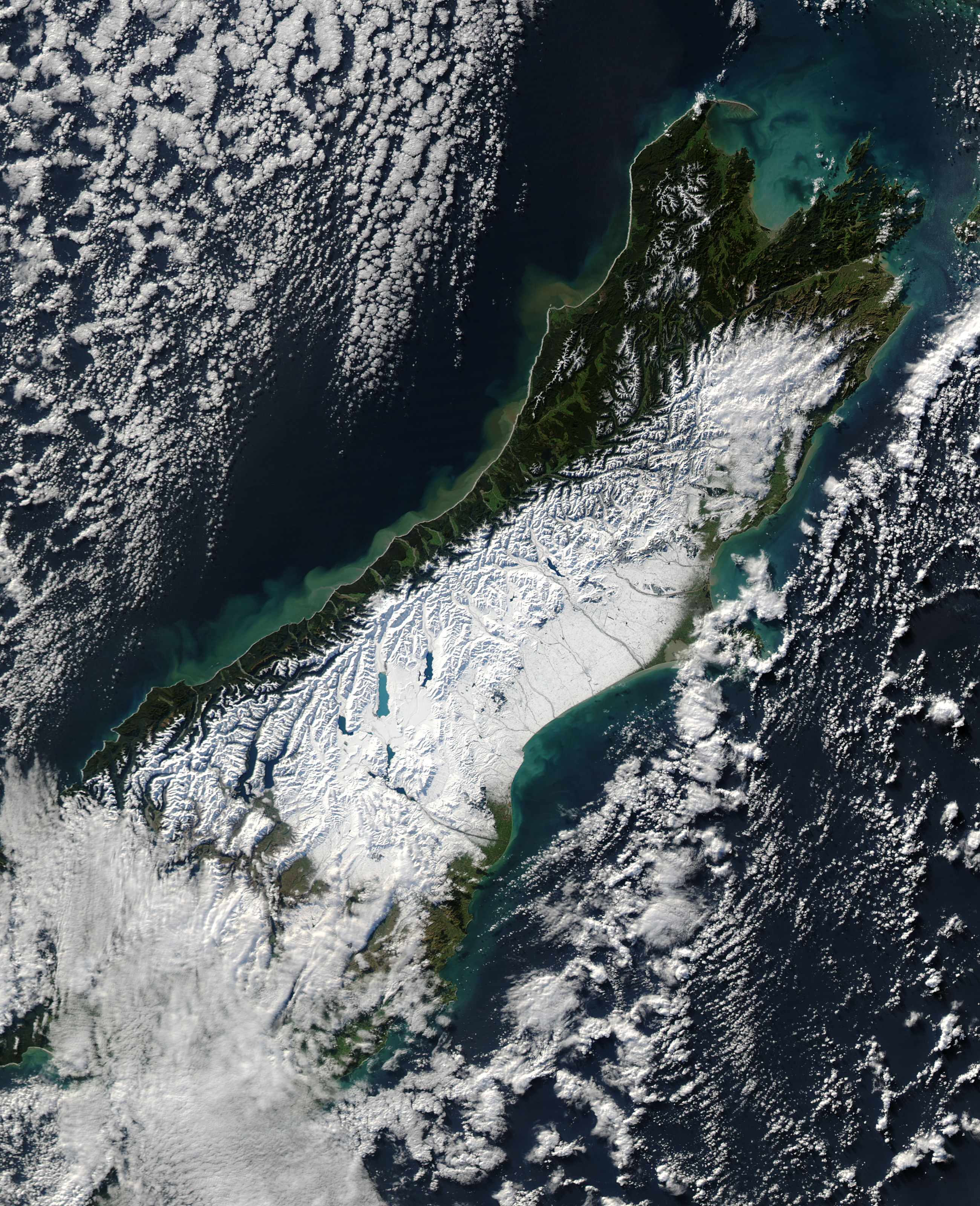
Satellite image of the South Island of New Zealand in June 2006. NASA's description:
- A powerful winter storm swept across New Zealand on June 12, 2006. The storm brought strong winds that gusted up to 130 kilometers per hour (80 miles per hour) and at least one tornado, reported the Australian Broadcasting Corporation (ABC). Heavy rains triggered floods and landslides along the western coast of South Island, and snow blanketed the central part of the island. This wild weather, said the ABC, knocked out power in Auckland, on North Island (not pictured), and throughout the Canterbury region, shown here.
- On June 13, skies were clear when the Moderate Resolution Imaging Spectroradiometer (MODIS) on NASA’s Aqua satellite captured this photo-like image of South Island, New Zealand. Snow covers the Southern Alps, making the finger-like glacier lakes stand out like sapphires against a field of white. The snow stretches to the sea on the east side of the island. It is here, in the river basins and valleys east of the mountains and around Christchurch, that deep snow closed roads and isolated communities, say news reports.
- The impact of heavy rain along the western shore of South Island is also evident in this image. Mud-laden water, full of sediment from landslides and run-off, flows into the Tasman Sea from the many streams that run out of the mountains. In the ocean, the muddy water is tan and fades to a cloudy green as the sediment disperse
Source: [4]
Historique du fichier
Cliquer sur une date et une heure pour voir le fichier tel qu’il était à ce moment-là
| Date et heure | Dimensions | Utilisateur | Commentaire | |
|---|---|---|---|---|
| actuel | 20 juin 2006 à 13:47 | 2 600×3 200 (2,08 Mio) | Brian | ({{PD-USGov-NASA}} Satellite image of the w:South Island of w:New Zealand in June 2005. NASA's description: :A powerful winter storm swept across New Zealand on June 12, 2006. The storm brought strong winds that gusted up to 130 kilometers per h) |
Pages contenant l’image
Les pages ci-dessous contiennent cette image :

