Image:Satellite image of Antigua And Barbuda in September 2002.jpg
Un article de Wikipédia, l'encyclopédie libre.
Pas de plus haute résolution disponible.
Satellite_image_of_Antigua_And_Barbuda_in_September_2002.jpg (311 × 372 pixels, taille du fichier : 16 Kio, type MIME : image/jpeg)
| | Ce fichier provient de Wikimedia Commons?. Les informations le concernant sont affichées ci-dessous (procédure). |
| Description |
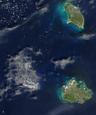
Cropped satellite image, showing the three islands of Antigua And Barbuda. |
|---|---|
| Source |
Cropped from: http://visibleearth.nasa.gov/view_rec.php?id=4342 |
| Date |
2002-10-16 |
| Author |
Jacques Descloitres, MODIS Rapid Response Team, NASA/GSFC |
| Permission (Reusing this image) |
see below |
[edit] Licensing
|
|
This file is in the public domain because it was created by NASA. NASA copyright policy states that "NASA material is not protected by copyright unless noted". (NASA copyright policy page or JPL Image Use Policy).
Deutsch | English | Español | Français | Nederlands | Português | Русский | 中文(简体) | 中文(繁體) | +/- |
|
 |
Warnings:
|
Historique du fichier
Cliquer sur une date et une heure pour voir le fichier tel qu’il était à ce moment-là
| Date et heure | Dimensions | Utilisateur | Commentaire | |
|---|---|---|---|---|
| actuel | 18 décembre 2004 à 16:26 | 311×372 (16 Kio) | Hautala | ({{PD-USGov-NASA}} Cropped satellite image, showing the three islands of Antigua And Barbuda. Original image taken from NASA's Visible Earth http://visibleearth.nasa.gov/cgi-bin/viewrecord?21888) |
Pages contenant l’image
La page ci-dessous contient cette image :

