Image:Rodrigues 76.jpg
Un article de Wikipédia, l'encyclopédie libre.
Pas de plus haute résolution disponible.
Rodrigues_76.jpg (430 × 427 pixels, taille du fichier : 51 Kio, type MIME : image/jpeg)
| | Ce fichier provient de Wikimedia Commons?. Les informations le concernant sont affichées ci-dessous (procédure). |
[edit] Summary
| Description |
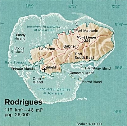
Deutsch: Karte von Rodrigues (Mauritius) im Indischen Ozean
English: Map of Rodrigues Island (Mauritius) in the Indian Ocean
|
|---|---|
| Source |
Taken from Perry-Castañeda Library (PCL) (http://www.lib.utexas.edu/maps/islands_oceans_poles/cargados_carajos_76.jpg), originally from CIA Indian Ocean Atlas |
| Date |
1976 |
| Author |
Tom Radulovich |
| Permission (Reusing this image) |
PD, see licensing |
[edit] Licensing
| This image is a work of a Central Intelligence Agency employee, taken or made during the course of the person's official duties. As a Work of the United States Government, all images created or made by the CIA are in the public domain, with the exception of classified information. |  |
Historique du fichier
Cliquer sur une date et une heure pour voir le fichier tel qu’il était à ce moment-là
| Date et heure | Dimensions | Utilisateur | Commentaire | |
|---|---|---|---|---|
| actuel | 14 juillet 2005 à 14:04 | 430×427 (51 Kio) | Sacalavou | (({{PD-USGov-CIA}} Map of Rodrigues Island, by Tom Radulovich 1976) |
Pages contenant l’image
La page ci-dessous contient cette image :

