Image:Polar low.jpg
Un article de Wikipédia, l'encyclopédie libre.
Pas de plus haute résolution disponible.
Polar_low.jpg (480 × 463 pixels, taille du fichier : 38 Kio, type MIME : image/jpeg)
| | Ce fichier provient de Wikimedia Commons?. Les informations le concernant sont affichées ci-dessous (procédure). |
[edit] Sumario
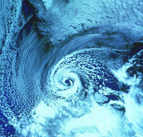
A NOAA-9 polar orbiter satellite image (visible band) of a polar low over the Barents Sea on 27 February 1987. The southern tip of Spitsbergen is visible at the top of the image. The polar low is centered just north of the Norwegian coast. [1]
Imported from the English Wikipedia
[edit] Licensing
| This work is in the public domain in the United States because it is a work of the United States Federal Government under the terms of Title 17, Chapter 1, Section 105 of the US Code. See Copyright.
Note: This only applies to works of the Federal Government and not to the work of any individual U.S. state, territory, commonwealth, county, municipality, or any other subdivision. العربية | Български | Česky | Deutsch | English | Español | Français | Magyar | Italiano | 日本語 | 한국어 | Polski | Português | 中文(繁體) | 中文(简体) | +/- |
 |
Historique du fichier
Cliquer sur une date et une heure pour voir le fichier tel qu’il était à ce moment-là
| Date et heure | Dimensions | Utilisateur | Commentaire | |
|---|---|---|---|---|
| actuel | 7 juin 2006 à 17:37 | 480×463 (38 Kio) | Hastings | (A NOAA-9 polar orbiter satellite image (visible band) of a polar low over the Barents Sea on 27 February 1987. The southern tip of Spitsbergen is visible at the top of the image. The polar low is centered just north of the Norwegian coast. [1]) |
Pages contenant l’image
Les pages ci-dessous contiennent cette image :

