Image:Plan Odendaal.png
Un article de Wikipédia, l'encyclopédie libre.
Pas de plus haute résolution disponible.
Plan_Odendaal.png (418 × 418 pixels, taille du fichier : 15 Kio, type MIME : image/png)
| | Ce fichier provient de Wikimedia Commons?. Les informations le concernant sont affichées ci-dessous (procédure). |
[edit] Summary
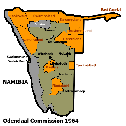
Español: Bantustanes en el territorio de Namibia con Damaraland al noroeste del país
This map shows the Odendaal Commission Plan for Namibia of 1964. The plan divided Namibia into Bantustans or Homelands.
I have created the map for the Wikipedia community.
French version : Image:Plan_Odendaal-fr.png

Historique du fichier
Cliquer sur une date et une heure pour voir le fichier tel qu’il était à ce moment-là
| Date et heure | Dimensions | Utilisateur | Commentaire | |
|---|---|---|---|---|
| actuel | 21 avril 2005 à 09:40 | 418×418 (15 Kio) | Bries | (This map shows the Odendaal Commission Plan for Namibia of 1964. The plan divided Namibia into ''Bantustans'' or ''Homelands''. I have created the map for the Wikipedia community. Category:Maps of Namibia {{GFDL}}) |
Pages contenant l’image
La page ci-dessous contient cette image :

