Image:Ph physical map.png
Un article de Wikipédia, l'encyclopédie libre.
Taille de cet aperçu : 382 × 598 pixels
Image en plus haute résolution (600 × 940 pixels, taille du fichier : 114 Kio, type MIME : image/png)
| | Ce fichier provient de Wikimedia Commons?. Les informations le concernant sont affichées ci-dessous (procédure). |
This is a featured picture on English Wikipedia and is considered one of the finest images.
|
 |
This map image should be recreated using vector graphics as an SVG file. This has several advantages; see Commons:Media for cleanup for more information. If an SVG form of this image is already available, please upload it. After uploading an SVG, replace this template with template {{Vector version available|new image name.svg}} in this image. |
|
العربية | Български | Català | Česky | Dansk | Deutsch | English | Esperanto | Español | Français | 한국어 | Italiano | Magyar | Lietuvių | Nederlands | 日本語 | Polski | Português | Română | Русский | Suomi | Svenska | Türkçe | Українська | Tiếng Việt | मराठी | 中文(繁體) | 中文(简体) | +/- |
|
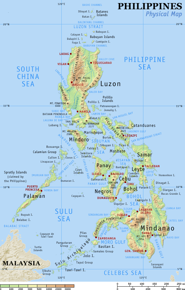
Physical map of the Philippines, showing all the major and some minor islands, bodies of water, mountains, and some major cities.
See blank version which can be used for other language Wikipedias. See also the small version.
Created and copyright (2003) by seav. Released under the GNU FDL.
Source: English Wikipedia, original upload see file history

[edit] File history English Wikipedia
(del) (cur) 15:09, 29 August 2005 . . Riumplus (117068 bytes) (Removed unused colours in the PNG palette, losslessly shrinking file size by 4%)
(del) (rev) 09:09, 25 July 2004 . . Guanaco (121976 bytes) (optimize)
(del) (rev) 08:46, 17 August 2003 . . Seav (122906 bytes) (Updated map with more details)
(del) (rev) 11:13, 20 June 2003 . . Seav (130670 bytes) (Physical map of the Philippines.)
Historique du fichier
Cliquer sur une date et une heure pour voir le fichier tel qu’il était à ce moment-là
| Date et heure | Dimensions | Utilisateur | Commentaire | |
|---|---|---|---|---|
| actuel | 2 mars 2007 à 00:05 | 600×940 (114 Kio) | Tene | (Optimised (0)) |
| 16 septembre 2005 à 19:21 | 600×940 (114 Kio) | Saperaud | (Physical map of the Philippines, showing all the major and some minor islands, bodies of water, mountains, and some major cities. See blank version which can be used for other language) |
Pages contenant l’image
Les pages ci-dessous contiennent cette image :

