Image:Oenosatellite.png
Un article de Wikipédia, l'encyclopédie libre.
Pas de plus haute résolution disponible.
Oenosatellite.png (530 × 532 pixels, taille du fichier : 298 Kio, type MIME : image/png)
| | Ce fichier provient de Wikimedia Commons?. Les informations le concernant sont affichées ci-dessous (procédure). |
[edit] Information
| Description |
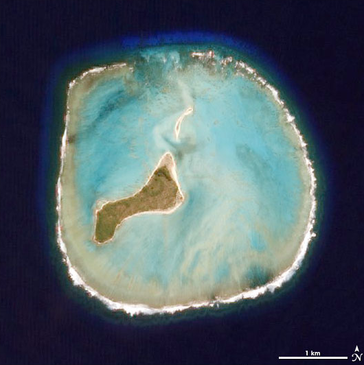
Deutsch: NASA-Satellitenbild des Oeno-Atolls im Pazifischen Ozean
English: NASA Satellite Picture of Oeno Island in the Pacific Ocean
Taken by the Advanced Land Imager on NASA’s EO-1 satellite as part of a Mid-decadal Global Land Survey. |
|---|---|
| Source |
http://earthobservatory.nasa.gov/Newsroom/NewImages/images.php3?img_id=17349 |
| Date |
16 June 2006 |
| Author |
NASA |
| Permission (Reusing this image) |
PD, see licensing |
[edit] Licensing
|
|
This file is in the public domain because it was created by NASA. NASA copyright policy states that "NASA material is not protected by copyright unless noted". (NASA copyright policy page or JPL Image Use Policy).
Deutsch | English | Español | Français | Nederlands | Português | Русский | 中文(简体) | 中文(繁體) | +/- |
|
 |
Warnings:
|
[edit] Original Upload Log
Original Uploader: en:User:Ryanjo at 3 August 2006.
Historique du fichier
Cliquer sur une date et une heure pour voir le fichier tel qu’il était à ce moment-là
| Date et heure | Dimensions | Utilisateur | Commentaire | |
|---|---|---|---|---|
| actuel | 29 novembre 2007 à 09:11 | 530×532 (298 Kio) | Telim tor | (== Information == {{Information |Description= {{de|NASA-Satellitenbild des Oeno-Atolls im Pazifischen Ozean}} {{en|NASA Satellite Image of Oeno Atoll in the Pacific Ocean}} Taken by the Advanced Land Imager on NASA’s EO-1 satellite as part of a Mid-deca) |
Pages contenant l’image
La page ci-dessous contient cette image :

