Image:Northern icesheet-fr.png
Un article de Wikipédia, l'encyclopédie libre.

Taille de cet aperçu : 800 × 587 pixels
Image en plus haute résolution (2 236 × 1 640 pixels, taille du fichier : 402 Kio, type MIME : image/png)
| | Ce fichier provient de Wikimedia Commons?. Les informations le concernant sont affichées ci-dessous (procédure). |
[edit] Summary
| Description |
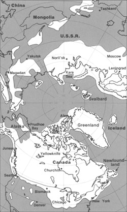
Northern hemisphere glaciation during the last ice ages. The set up of 3 to 4 km thick ice sheets caused a sea level lowering of about 120 m. Also the Alps and the Himalaya were covered by glaciers. The limit of winter sea ice coverage was much more to the south. |
|---|---|
| Source |
Image:Northern_icesheet_hg.png created by Hannes Grobe |
| Date |
2000-04-07, modified October 2006 |
| Author |
Hannes Grobe 23:06, 21 July 2006 (UTC), Alfred Wegener Institute for Polar and Marine Research, Bremerhaven, Germany, translated by Sting |
| Permission (Reusing this image) |
share alike, attribution required (Creative Commons CC-BY-SA-2.5) |
| Other versions | in English : Image:Northern_icesheet_hg.png USGS map |
Français :
- Sujet : Carte de l'hémisphère nord durant la dernière glaciation. Une couche de glace de 3 à 4 km d'épaisseur a entraîné un abaissement du niveau de la mer d'environ 120 m. Les Alpes et l'Himalaya étaient recouverts par des glaciers. L'extension de la banquise en hiver allait bien plus au Sud qu'actuellement ;
- Source : Image:Northern_icesheet_hg.png créée par Hannes Grobe ;
- Auteur : Hannes Grobe, cette version par fr:Sting ;
- Date : Avril 2000, modifications : octobre 2006 ;
- Version originale anglophone : Image:Northern_icesheet_hg.png ;
- Version alternative : carte USGS (lien externe).
English: This map was made or improved by the Wikigraphists of the Atelier graphique. You can propose maps or images to clean up and improve as well.
Esperanto: Ĉi tiu mapo estis kreita aŭ plibonigita de la Vikigrafistoj el la Grafika laborgrupo. Vi ankaŭ povas tie proponi mapojn aŭ bildojn plibonigendajn.
Español: Este mapa ha sido confeccionado o mejorado por los Wikígrafos del Taller gráfico. Puedes proponer la mejora de cualquier imagen a través de la página de Peticiones.
Français : Cette carte a été créée ou améliorée par les Wikigraphistes de l'Atelier graphique. Vous pouvez également y proposer des cartes ou des images à améliorer.
Türkçe: Bu harita Atelier graphique'ten Wikigraphistes'ler tarafından yapıldı veya geliştirildi. Siz de haritalar veya resimleri temizlemek veya geliştirmek için teklif edebilirsiniz.
[edit] Licensing
| This file is licensed under the Creative Commons Attribution ShareAlike 2.5 License. In short: you are free to share and make derivative works of the file under the conditions that you appropriately attribute it, and that you distribute it only under a license identical to this one. Official license |
Historique du fichier
Cliquer sur une date et une heure pour voir le fichier tel qu’il était à ce moment-là
| Date et heure | Dimensions | Utilisateur | Commentaire | |
|---|---|---|---|---|
| actuel | 22 octobre 2006 à 21:16 | 2 236×1 640 (402 Kio) | Sting | ({{Information| |Description=Northern hemisphere glaciation during the last ice ages. The set up of 3 to 4 km thick ice sheets caused a sea level lowering of about 120 m. Also the Alps and the Himalya were covered by glaciers. The limit of winter sea ice c) |
Pages contenant l’image
Les pages ci-dessous contiennent cette image :

