Image:North-Pacific-air-routes.png
Un article de Wikipédia, l'encyclopédie libre.
Pas de plus haute résolution disponible.
North-Pacific-air-routes.png (500 × 441 pixels, taille du fichier : 34 Kio, type MIME : image/png)
| | Ce fichier provient de Wikimedia Commons?. Les informations le concernant sont affichées ci-dessous (procédure). |
La bildo estas kopiita de wikipedia:en. La originala priskribo estas:
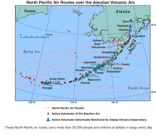
North Pacific air routes over the Aleutian volcanic arc.[1] From the Alaska Volcano Observatory, a joint program of the United States Geological Survey, the Geophysical Institute of the University of Alaska Fairbanks, and the State of Alaska Division of Geological and Geophysical Surveys. This image contained no copyright information and is assumed to be freely available as a USGS image.
| This image is in the public domain because it contains materials that originally came from the United States Geological Survey, an agency of the United States Department of Interior. For more information, see the official USGS copyright policy |
|
| date/time | username | edit summary |
|---|---|---|
| 01:16, 10 February 2005 | en:User:RedWolf | ({{PD-USGov-Interior-USGS}}) |
| 06:18, 4 September 2004 | en:User:Moverton | |
| 05:49, 4 September 2004 | en:User:Moverton | (North Pacific air routes over the Aleutian volcanic arc) |
[edit] Historio de la dosiero
Legend: (cur) = this is the current file, (del) = delete this old version, (rev) = revert to this old version.
Click on date to download the file or see the image uploaded on that date.
- (del) (cur) 05:49, 4 September 2004 . . en:User:Moverton Moverton ( en:User_talk:Moverton Talk) . . 500x441 (34601 bytes) (North Pacific air routes over the Aleutian volcanic arc)
Haylee is soooo hot and you better remember that:)
Historique du fichier
Cliquer sur une date et une heure pour voir le fichier tel qu’il était à ce moment-là
| Date et heure | Dimensions | Utilisateur | Commentaire | |
|---|---|---|---|---|
| actuel | 24 janvier 2006 à 21:44 | 500×441 (34 Kio) | Maksim | (La bildo estas kopiita de wikipedia:en. La originala priskribo estas: ''North Pacific air routes over the Aleutian volcanic arc.[http://www.avo.alaska.edu/avo4/atlas/volc/spurr/spurr2004/popup.htm?airroutes.jpg]'' From the [http://www.avo.alaska.edu/ Al) |
Pages contenant l’image
La page ci-dessous contient cette image :


![[1]](http://www.avo.alaska.edu/avo4/atlas/volc/spurr/spurr2004/popup.htm?airroutes.jpg)