Image:Nandrin Liège Belgium Map.png
Un article de Wikipédia, l'encyclopédie libre.
Pas de plus haute résolution disponible.
Nandrin_Liège_Belgium_Map.png (290 × 220 pixels, taille du fichier : 5 Kio, type MIME : image/png)
| | Ce fichier provient de Wikimedia Commons?. Les informations le concernant sont affichées ci-dessous (procédure). |
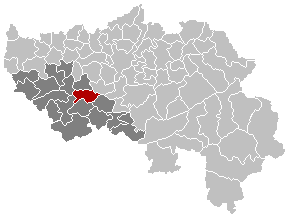
Map, municipality belgium Nandrin
| This image has been released into the public domain by its author, LennartBolks. This applies worldwide. In some countries this may not be legally possible; if so: العربية | Български | Deutsch | Ελληνικά | English | Español | Français | Italiano | 日本語 | 한국어 | Polski | Русский | Српски / Srpski | Svenska | தமிழ் | Українська | 中文(繁體) | 中文(简体) +/- |
FR; Carte indiquant la localisation de la commune de Nandrin dans la Province de Liège.
EN; Map from w:nl:Gebruiker:LennartBolks/kaartenhoekje in Public Domain by the Author choice.
Historique du fichier
Cliquer sur une date et une heure pour voir le fichier tel qu’il était à ce moment-là
| Date et heure | Dimensions | Utilisateur | Commentaire | |
|---|---|---|---|---|
| actuel | 27 novembre 2005 à 23:09 | 290×220 (5 Kio) | Srtxg | (arrondissement in dark) |
| 4 avril 2005 à 23:08 | 290×220 (5 Kio) | Nicnac25 | (Map, municipality belgium Nandrin {{PD}} FR; Carte indiquant la localisation de la commune de Nandrin dans la Province de Liège. EN; Map from w:nl:Gebruiker:LennartBolks/kaartenhoekje in Public Domain by the Author choice. [[Category:Maps of provin) |
Pages contenant l’image
Les pages ci-dessous contiennent cette image :

