Image:Mountain passes of Afghanistan.png
Un article de Wikipédia, l'encyclopédie libre.
Pas de plus haute résolution disponible.
Mountain_passes_of_Afghanistan.png (514 × 450 pixels, taille du fichier : 39 Kio, type MIME : image/png)
| | Ce fichier provient de Wikimedia Commons?. Les informations le concernant sont affichées ci-dessous (procédure). |
[edit] Summary
| Description |
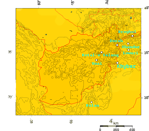
Mountain_passes_of_Afghanistan |
|---|---|
| Source |
self-made |
| Date |
April 23, 2007 |
| Author | |
| Permission (Reusing this image) |
see below |
[edit] geographic coordinates used...
I used this tool to make this map, and used the geographic locations of the existing articles.
If we add more mountain passes it should be easy to create a new version of the map with those passes...
| 73.4333, | 37, | Broghol |
| 71.233, | 36.0838, | Dorah Pass |
| 72.755, | 36.159, | Shandur Top |
| 72.7545, | 35.46, | Lowari Pass |
| 67.6, | 29.75, | Bolan Pass |
| 69.0502, | 35.3211, | Kotal-e Salang |
| 68.329, | 34.467, | Unai Pass |
| 71.1583, | 34.0839, | Khyber Pass |
[edit] Licensing
|

Historique du fichier
Cliquer sur une date et une heure pour voir le fichier tel qu’il était à ce moment-là
| Date et heure | Dimensions | Utilisateur | Commentaire | |
|---|---|---|---|---|
| actuel | 24 avril 2007 à 09:37 | 514×450 (39 Kio) | Geo Swan | ({{Information |Description= |Source= |Date= |Author= }} ) |
| 23 avril 2007 à 16:39 | 514×535 (26 Kio) | Geo Swan | ({{Information |Description=Mountain_passes_of_Afghanistan |Source=self-made |Date=April 23, 2007 |Author= User:Geo Swan }} ) |
Pages contenant l’image
Les pages ci-dessous contiennent cette image :

