Image:Mississippi Delta Lobes.jpg
Un article de Wikipédia, l'encyclopédie libre.
Pas de plus haute résolution disponible.
Mississippi_Delta_Lobes.jpg (800 × 484 pixels, taille du fichier : 73 Kio, type MIME : image/jpeg)
| | Ce fichier provient de Wikimedia Commons?. Les informations le concernant sont affichées ci-dessous (procédure). |
From : http://en.wikipedia.org/wiki/Image:Mississippi_Delta_Lobes.jpg
|
|
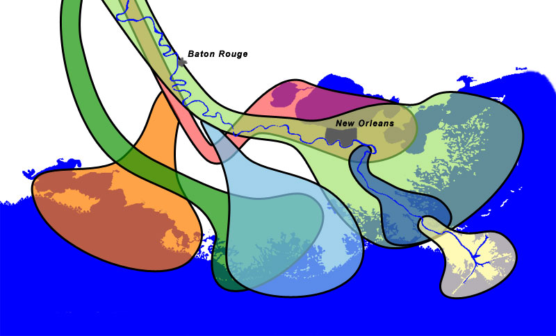
Salé-Cypremort | 4600 years BP |
|
|
Cocodrie | 4600-3500 years BP |
|
|
Teche | 3500-2800 years BP |
|
|
St. Bernard | 2800-1000 years BP |
|
|
Lafourche | 1000-300 years BP |
|
|
Plaquemine | 750-500 years BP |
|
|
Balize | 550 years |
[edit] Description
The lobes of the Mississippi River Delta that formed over thousands of years due to deltaic switching.
[edit] Sources
- Wicander,Monroe (1993). Historical Geology - Evolution of Earth and Life through Time. West Publishing Company. ISBN 0314012400. [1]
- Kolb,van Lopik (1958). Geology of the Mississippi River deltaic plain, southeastern Louisiana. Technical Report 3-483. Vicksburg, MS: U.S. Army Corps of Engineers Waterways Experiment Station. (PDF, 6.86MB) [2]
- Delta Complexes of Mississippi River Deltaic Plain, Frazier, 1967 [3]
[edit] Licensing
| I, the copyright holder of this work, hereby release it into the public domain. This applies worldwide. In case this is not legally possible: Afrikaans | Alemannisch | Aragonés | العربية | Asturianu | Български | Català | Česky | Cymraeg | Dansk | Deutsch | Eʋegbe | Ελληνικά | English | Español | Esperanto | Euskara | Estremeñu | فارسی | Français | Galego | 한국어 | हिन्दी | Hrvatski | Ido | Bahasa Indonesia | Íslenska | Italiano | עברית | Kurdî / كوردی | Latina | Lietuvių | Latviešu | Magyar | Македонски | Bahasa Melayu | Nederlands | Norsk (bokmål) | Norsk (nynorsk) | 日本語 | Polski | Português | Ripoarisch | Română | Русский | Shqip | Slovenčina | Slovenščina | Српски / Srpski | Svenska | ไทย | Tagalog | Türkçe | Українська | Tiếng Việt | Walon | 中文(简体) | 中文(繁體) | zh-yue-hant | +/- |
Coast and river images from the National Map Server. Lobe outlines originally traced directly from Wicander and Monroe, 1993, but the shorline and river didn't match the USGS data, so the outlines had to be reinterpretted slightly.
Final Photoshop layers can be found here, in case updates are needed.
Historique du fichier
Cliquer sur une date et une heure pour voir le fichier tel qu’il était à ce moment-là
| Date et heure | Dimensions | Utilisateur | Commentaire | |
|---|---|---|---|---|
| actuel | 30 décembre 2006 à 14:51 | 800×484 (73 Kio) | Urban | (From : http://en.wikipedia.org/wiki/Image:Mississippi_Delta_Lobes.jpg {| |<div class="key" style="background-color:#FFA447; width:1.5em; height:1.5em; border: 2px solid black"> </div> |Salé-Cypremort |4600 years [) |
Pages contenant l’image
La page ci-dessous contient cette image :

