Image:Mississippi-Coast-towns-NOAA.jpg
Un article de Wikipédia, l'encyclopédie libre.
Pas de plus haute résolution disponible.
Mississippi-Coast-towns-NOAA.jpg (750 × 382 pixels, taille du fichier : 57 Kio, type MIME : image/jpeg)
| | Ce fichier provient de Wikimedia Commons?. Les informations le concernant sont affichées ci-dessous (procédure). |
[edit] Summary
| Description |
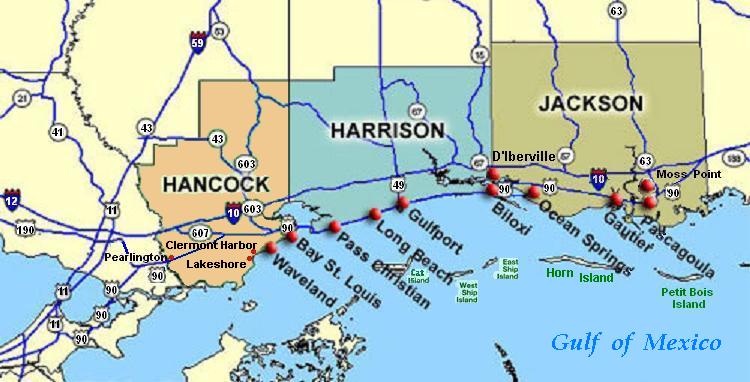
Coastal map of the U.S. state of Mississippi, showing major towns and cities in the 3 coastal counties: Hancock, Harrison, and Jackson County. Also shown are Cat Island, West Ship Island, East Ship Island, Horn Island and Petit Bois Island.The locations of towns, roads and offshore islands are based on NOAA and NASA maps. |
|---|---|
| Source |
self-made (hand-edited with MS-Paint)
The map is in quick JPEG format, for large display as highly readable, in about 20 articles that display the map. JPEG clarity is enhanced by painted areas behind many labels, causing the wording to be clearer than even a massive SVG or PNG-format file could provide, due to the sharp display contrast of JPEG files. JPEG Clarity: Even though JPEG images have artifacts, they can display clearer wording in small maps due to auto-contrast enhancement. The same painted/shaded areas, that illuminate wording, would make the map excessively gargantuan in slow cumbersome PNG or SVG format, as is the case with terrain maps, which also should NEVER be converted to massive PNG format. |
| Date |
21-June-2007 |
| Author | |
| Permission (Reusing this image) |
(see below) |
This image was (or all images in this article or category were) uploaded in the JPEG format.
However, it contains information that could be stored more efficiently or more accurately in the PNG format or SVG format. If possible, please upload a PNG or SVG version of this image without compression artifacts, derived from a non-JPEG source or with existing artifacts removed. After doing so, please:
- Find all pages in all Wikimedia projects that use this image, and replace the old image with the new image in each.
- Mark this image as having been superseded by adding one of these templates.
Deutsch | English | Español | Français | 日本語 | Português | Русский | +/-
[edit] Licensing
| I, Wikid77, the copyright holder of this work, hereby release it into the public domain. This applies worldwide. In case this is not legally possible: Afrikaans | Alemannisch | Aragonés | العربية | Asturianu | Български | Català | Česky | Cymraeg | Dansk | Deutsch | Eʋegbe | Ελληνικά | English | Español | Esperanto | Euskara | Estremeñu | فارسی | Français | Galego | 한국어 | हिन्दी | Hrvatski | Ido | Bahasa Indonesia | Íslenska | Italiano | עברית | Kurdî / كوردی | Latina | Lietuvių | Latviešu | Magyar | Македонски | Bahasa Melayu | Nederlands | Norsk (bokmål) | Norsk (nynorsk) | 日本語 | Polski | Português | Ripoarisch | Română | Русский | Shqip | Slovenčina | Slovenščina | Српски / Srpski | Svenska | ไทย | Tagalog | Türkçe | Українська | Tiếng Việt | Walon | 中文(简体) | 中文(繁體) | zh-yue-hant | +/- |
Historique du fichier
Cliquer sur une date et une heure pour voir le fichier tel qu’il était à ce moment-là
| Date et heure | Dimensions | Utilisateur | Commentaire | |
|---|---|---|---|---|
| actuel | 26 juin 2007 à 04:54 | 750×382 (57 Kio) | Wikid77 | (Brown-toned map: Hancock County as tan (was green); put "Gulf of Mexico" Antigua font; shift labels on islands) |
| 26 juin 2007 à 02:17 | 750×382 (56 Kio) | Wikid77 | (Mississippi coastal map, with "Horn Island" relabeled, clarified Hwy "90" and "63" icons.) | |
| 21 juin 2007 à 20:56 | 750×382 (56 Kio) | Wikid77 | (re-load of image file, in case internal data was garbled) | |
| 21 juin 2007 à 20:11 | 750×382 (56 Kio) | Wikid77 | ({{Information |Description=Coastal map of the U.S. state of en:Mississippi, showing major towns and cities in the 3 coastal counties: Hancock, Harrison, a) |
Pages contenant l’image
La page ci-dessous contient cette image :

