Image:Mapcarpat2.png
Un article de Wikipédia, l'encyclopédie libre.
Pas de plus haute résolution disponible.
Mapcarpat2.png (442 × 395 pixels, taille du fichier : 12 Kio, type MIME : image/png)
| | Ce fichier provient de Wikimedia Commons?. Les informations le concernant sont affichées ci-dessous (procédure). |
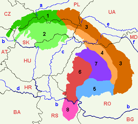
- Map of the main divisions of the Carpathian Mountains.
- Annotated version of image file Image:Mapcarpat.png
- Legend
Divisions of the Carpathians, in black numbers:
- 1, dark green: Outer Western Carpathians
- 2, light green: Inner Western Carpathians
- 3, dark orange: Outer Eastern Carpathians
- 4, light orange: Inner Eastern Carpathians
- 5, light blue: Southern Carpathians
- 6, red: Western Romanian Carpathians
- 7, purple: Transylvanian Plateau
- 8, pink: Serbian Carpathians
Rivers, in blue lower case letters:
- a: Vistula
- b: Danube
- c: Tisza
- d: Sava
- e: Dniester
- f: Prut
Countries (ISO 3166-1 alpha-2 codes), in red upper case letters:
- CZ: Czechia
- PL: Poland
- UA: Ukraine
- AT: Austria
- SK: Slovakia
- HU: Hungary
- RO: Romania
- HR: Croatia
- BA: Bosnia and Herzegovina
- RS: Serbia
- BG: Bulgaria

Historique du fichier
Cliquer sur une date et une heure pour voir le fichier tel qu’il était à ce moment-là
| Date et heure | Dimensions | Utilisateur | Commentaire | |
|---|---|---|---|---|
| actuel | 24 mai 2007 à 10:23 | 442×395 (12 Kio) | Zeman | ({{Information |Description= |Source=self-made |Date= |Author= User:Zeman }}) |
| 12 juillet 2005 à 13:52 | 442×395 (9 Kio) | Markussep | (ISO 3166-1 alpha-2 country codes) | |
| 12 juillet 2005 à 13:32 | 442×395 (9 Kio) | Markussep | (Annotated version of image file Mapcarpat.png) |
Pages contenant l’image
Les pages ci-dessous contiennent cette image :

