Image:Mapa 2 paktu Ribbentrop-Mołotow.gif
Un article de Wikipédia, l'encyclopédie libre.
Taille de cet aperçu : 432 × 600 pixels
Image en plus haute résolution (510 × 708 pixels, taille du fichier : 22 Kio, type MIME : image/gif)
| | Ce fichier provient de Wikimedia Commons?. Les informations le concernant sont affichées ci-dessous (procédure). |
[edit] Summary
| Description |
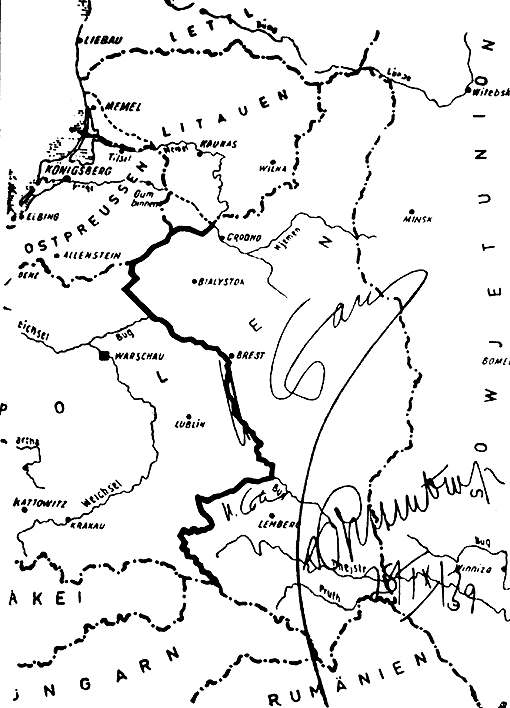
Deutsch: Karte aus dem geheimen Zusatzprotokolls des Deutsch-sowjetischen Nichtangriffspakts, der die vorgesehene Teilung Polens zeigt. Die Karte ist unterschrieben von Josef Stalin und Reichsaußenminister Joachim von Ribbentrop.
English: The map from the secret appendix to the Molotov-Ribbentrop Pact showing the new German-Soviet border. The map is signed by Joseph Stalin and German Foreign Minister Joachim von Ribbentrop.
|
|---|---|
| Source |
This photo of the document was made in 1946 by the defence of von Ribbentrop and Hermann Göring in the Nuremberg Trials in 1946. |
| Date |
1939-09-28 (document), 1946 (photo) |
| Author |
Unknown |
| Permission (Reusing this image) |
Public domain |
[edit] Licensing
| This file is in the public domain, because This is a German photograph now well over 50 years old. Under Germany's copyright law, Article 72, this means that any copyright has expired. In case this is not legally possible:
|
Historique du fichier
Cliquer sur une date et une heure pour voir le fichier tel qu’il était à ce moment-là
| Date et heure | Dimensions | Utilisateur | Commentaire | |
|---|---|---|---|---|
| actuel | 23 novembre 2006 à 22:27 | 510×708 (22 Kio) | Andros64 | (Second Ribentropp-Molotov Pact.28.09.1939. Map of Poland signed by Stalin an Ribentropp with new German-Soviet border. Author unknown. This is photo of document made in 1946 for Nurnberg Trial purposes ( German origin - defence of Ribentropp and Goring)) |
Pages contenant l’image
La page ci-dessous contient cette image :

