Image:Map operation husky landing.jpg
Un article de Wikipédia, l'encyclopédie libre.

Taille de cet aperçu : 800 × 576 pixels
Image en plus haute résolution (806 × 580 pixels, taille du fichier : 134 Kio, type MIME : image/jpeg)
| | Ce fichier provient de Wikimedia Commons?. Les informations le concernant sont affichées ci-dessous (procédure). |
- Source: http://www.army.mil/cmh-pg/brochures/72-16/map1.JPG
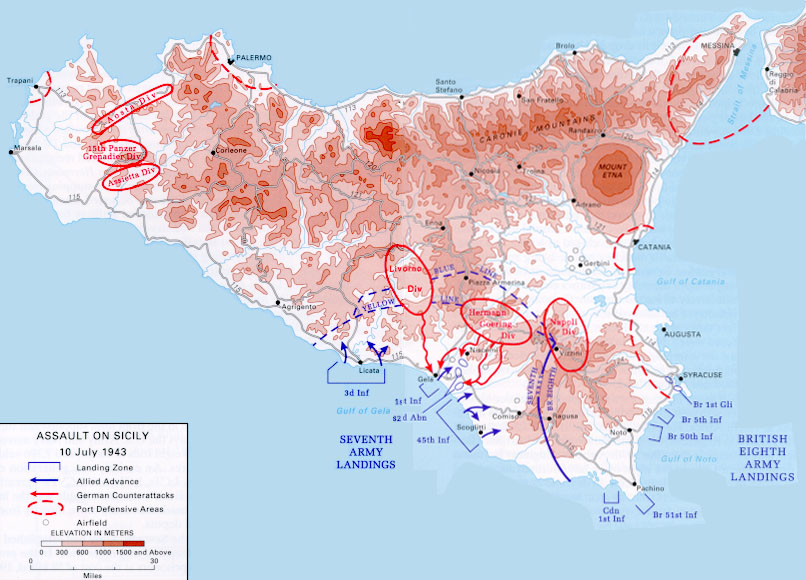
- Description: This is a map of the Allied army amphibious landing in Sicily, July 10th, 1943, as part of Operation Husky. It shows the deployments of the landing forces and the German and Italian formations defending the island.
- Reference: Army brochure — Sicily 1943
- Width: 806 pixels
- Height: 580 pixels
| This image is a work of a U.S. military or Department of Defense employee, taken or made during the course of an employee's official duties. As a work of the U.S. federal government, the image is in the public domain. See the DoD copyright policy. |
 |
Historique du fichier
Cliquer sur une date et une heure pour voir le fichier tel qu’il était à ce moment-là
| Date et heure | Dimensions | Utilisateur | Commentaire | |
|---|---|---|---|---|
| actuel | 6 avril 2005 à 12:28 | 806×580 (134 Kio) | Greuff | (*'''Source:''' http://www.army.mil/cmh-pg/brochures/72-16/map1.JPG *'''Description:''' This is a map of the Allied army amphibious landing in Sicily, July 10th, 1943, as part of Operation Husky. It shows the deployments of the landing forc) |
Pages contenant l’image
La page ci-dessous contient cette image :

