Image:Map of USA highlighting Corn Belt.png
Un article de Wikipédia, l'encyclopédie libre.
Pas de plus haute résolution disponible.
Map_of_USA_highlighting_Corn_Belt.png (280 × 183 pixels, taille du fichier : 41 Kio, type MIME : image/png)
| | Ce fichier provient de Wikimedia Commons?. Les informations le concernant sont affichées ci-dessous (procédure). |
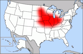
| Description |
Public domain map courtesy of The General Libraries, The University of Texas at Austin, modified (by • Benc • 00:30, 13 Aug 2004 (UTC)) to highlight regions. |
|---|---|
| Source |
Originally from en.wikipedia; description page is/was here. |
| Date |
2004-08-13 (original upload date) |
| Author |
Original uploader was Benc at en.wikipedia |
| Permission (Reusing this image) |
Released into the public domain (by the author). |
[edit] License information
| This image has been (or is hereby) released into the public domain by its author, Benc at the wikipedia project. This applies worldwide. In case this is not legally possible: |
[edit] Original upload log
(All user names refer to en.wikipedia)
- 2004-08-13 00:29 Benc 280×183×8 (41627 bytes) PD map, modified by myself
Historique du fichier
Cliquer sur une date et une heure pour voir le fichier tel qu’il était à ce moment-là
| Date et heure | Dimensions | Utilisateur | Commentaire | |
|---|---|---|---|---|
| actuel | 24 mars 2007 à 12:55 | 280×183 (41 Kio) | PDD | ({{Information |Description=Public domain map courtesy of [http://www.lib.utexas.edu/ The General Libraries, The University of Texas at Austin], modified (by • Benc • 00:30, 13 Aug 2004 (UTC)) to highlight regio) |
Pages contenant l’image
La page ci-dessous contient cette image :

