Image:Map of Luzerne County Pennsylvania School Districts.png
Un article de Wikipédia, l'encyclopédie libre.
Pas de plus haute résolution disponible.
Map_of_Luzerne_County_Pennsylvania_School_Districts.png (418 × 376 pixels, taille du fichier : 18 Kio, type MIME : image/png)
| | Ce fichier provient de Wikimedia Commons?. Les informations le concernant sont affichées ci-dessous (procédure). |
[edit] Summary
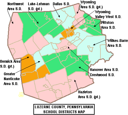
| Description |
Map of Luzerne County, Pennsylvania, United States Public School Districts |
|---|---|
| Source |
taken from US Census website [1] and modified by User:Ruhrfisch |
| Date |
May 2006 |
| Author |
US Census, Ruhrfisch |
| Permission (Reusing this image) |
US Census / US Government work is public domain, my modifications licensed under the GNU Free Documentation License |
[edit] Licensing

Historique du fichier
Cliquer sur une date et une heure pour voir le fichier tel qu’il était à ce moment-là
| Date et heure | Dimensions | Utilisateur | Commentaire | |
|---|---|---|---|---|
| actuel | 30 mai 2006 à 03:04 | 418×376 (18 Kio) | Ruhrfisch | (== Summary == {{Information| |Description= Map of Luzerne County, Pennsylvania, United States Public School Districts |Source= taken from US Census website [http://factfinder.census.gov/] and modified by User:Ruhrfisch |Date= May 2006 |Author= US Ce) |
| 22 mai 2006 à 22:56 | 418×376 (20 Kio) | Ruhrfisch | ({{Information| |Description= Map of Luzerne County, Pennsylvania, United States Public School Districts |Source= taken from US Census website [http://factfinder.census.gov/] and modified by User:Ruhrfisch |Date= May 2006 |Author= US Census, Ruhrfisc) |
Pages contenant l’image
La page ci-dessous contient cette image :

