Image:Map of Idaho highlighting the Idaho Panhandle.png
Un article de Wikipédia, l'encyclopédie libre.
Pas de plus haute résolution disponible.
Map_of_Idaho_highlighting_the_Idaho_Panhandle.png (197 × 300 pixels, taille du fichier : 19 Kio, type MIME : image/png)
| | Ce fichier provient de Wikimedia Commons?. Les informations le concernant sont affichées ci-dessous (procédure). |
| Description |
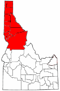
English: Modified from public domain map courtesy of The General Libraries, The University of Texas at Austin, modified to show counties, and further to show the en:Idaho Panhandle.
See en:Wikipedia:U.S. county maps. The image was modified from en::Image:Map of Idaho highlighting Fremont County.png by en:User:TShilo12. See that image for more © release information. |
|---|---|
| Source |
Transferred from en.wikipedia; Transfer was stated to be made by User:TCY. |
| Date |
2005-09-20 (original upload date) |
| Author |
Original uploader was TShilo12 at en.wikipedia |
| Permission (Reusing this image) |
GFDL-WITH-DISCLAIMERS; Released under the GNU Free Documentation License. |
[edit] License information
 |
Permission is granted to copy, distribute and/or modify this document under the terms of the GNU Free Documentation License, Version 1.2 or any later version published by the Free Software Foundation; with no Invariant Sections, no Front-Cover Texts, and no Back-Cover Texts. Subject to disclaimers. Asturianu | Български | Català | Deutsch | English | Español | Français | Gaeilge | Italiano | 한국어 | 日本語 | Polski | Português | Română | Türkçe | +/- |
[edit] Original upload log
The original description page is/was here. All following user names refer to en.wikipedia.
- 2005-09-20 04:00 TShilo12 197×300×8 (19061 bytes) Modified from public domain map courtesy of [http://www.lib.utexas.edu/ The General Libraries, The University of Texas at Austin], modified to show counties, and further to show the [[Idaho Panhandle]]. {{GFDL}} See [[Wikipedia:U.S. county map]]s. The im
Historique du fichier
Cliquer sur une date et une heure pour voir le fichier tel qu’il était à ce moment-là
| Date et heure | Dimensions | Utilisateur | Commentaire | |
|---|---|---|---|---|
| actuel | 29 février 2008 à 13:10 | 197×300 (19 Kio) | File Upload Bot (Magnus Manske) | ( {{BotMoveToCommons|en.wikipedia}} {{Information |Description={{en|Modified from public domain map courtesy of [http://www.lib.utexas.edu/ The General Libraries, The University of Texas at Austin], modified to show counties, and further to show the [[:en:) |
Pages contenant l’image
La page ci-dessous contient cette image :

