Image:Map indicating Baffin Bay.png
Un article de Wikipédia, l'encyclopédie libre.
Pas de plus haute résolution disponible.
Map_indicating_Baffin_Bay.png (425 × 365 pixels, taille du fichier : 68 Kio, type MIME : image/png)
| | Ce fichier provient de Wikimedia Commons?. Les informations le concernant sont affichées ci-dessous (procédure). |
[edit] Summary
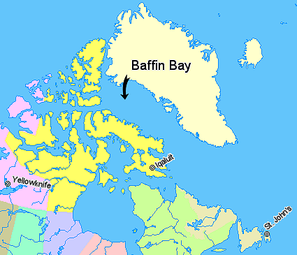
Map indicating Baffin Bay, lying between Greenland and Nunavut, Canada.
██ Nunavut
██ Quebec
██ Newfoundland and Labrador
██ Northwest Territories
██ Regions outside Canada (Greenland, Iceland)
© Her Majesty the Queen in Right of Canada, Department of Natural Resources. All rights reserved.
Licence Agreement
[edit] Licensing
 |
The copyright holder of this file allows anyone to use it for any purpose, provided that the copyright holder is properly attributed. Redistribution, derivative work, commercial use, and all other use is permitted.
Aragonés | العربية | Български | Català | Dansk | Deutsch | Ελληνικά | English | Español | Español | Français | עברית | Magyar | Galego | Italiano | 日本語 | 한국어 | Kurdî / كوردی | Latviešu | Nederlands | Norsk (bokmål) | Polski | Português | Svenska | Türkçe | Русский | 中文(简体) | 中文(繁體) | +/- |
m. .
Historique du fichier
Cliquer sur une date et une heure pour voir le fichier tel qu’il était à ce moment-là
| Date et heure | Dimensions | Utilisateur | Commentaire | |
|---|---|---|---|---|
| actuel | 21 mars 2006 à 05:40 | 425×365 (68 Kio) | David Kernow | (Map indicating Baffin Bay, lying between Greenland and Nunavut, Canada. {{legend|#ffff66|Nunavut}} {{legend|#d5fe94|Quebec}} {{legend|#ecebb6|Newfoundland and Labrador {{legend|#ffccff|Northwest Territories}} {{legend|#ffffcc|Regions out) |
Pages contenant l’image
Les pages ci-dessous contiennent cette image :

