Image:Map Provence 1184.jpg
Un article de Wikipédia, l'encyclopédie libre.
Pas de plus haute résolution disponible.
Map_Provence_1184.jpg (236 × 202 pixels, taille du fichier : 25 Kio, type MIME : image/jpeg)
| | Ce fichier provient de Wikimedia Commons?. Les informations le concernant sont affichées ci-dessous (procédure). |
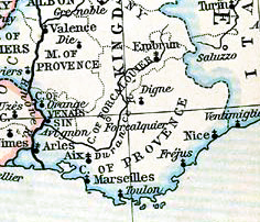
![]() : Map of County of Provence, in 1184
: Map of County of Provence, in 1184
![]() : Carte du comté de Provence, en 1184
: Carte du comté de Provence, en 1184
| This map come from the map collection of University of Texas and more exactly from this one : France, 1154-1184, from Historical Atlas by William R. Shepherd, 1911.. It is in public domain (http://www.lib.utexas.edu/maps/faq.html#3.html). | |
| Cette carte est issue issu de la collection de cartes de l'université du Texas et plus précisément de celle-ci : France, 1154-1184, from Historical Atlas by William R. Shepherd, 1911.. Elle se trouve dans dans le domaine public (http://www.lib.utexas.edu/maps/faq.html#3.html). | |
| Deze afbeelding is afkomstig uit de kaartencollectie van de University of Texas. Deze kaarten bevinden zich in het publiek domein (http://www.lib.utexas.edu/maps/faq.html#3.html). |
[edit] Licensing
| This work is in the public domain in the United States, and those countries with a copyright term of life of the author plus 70 years or less. |
Historique du fichier
Cliquer sur une date et une heure pour voir le fichier tel qu’il était à ce moment-là
| Date et heure | Dimensions | Utilisateur | Commentaire | |
|---|---|---|---|---|
| actuel | 15 septembre 2007 à 14:57 | 236×202 (25 Kio) | Odejea | (25px : Map of County of Provence, in 1184 25px : Carte du comté de v, en 1184 {{Template:U-Texas |url=http://www.lib.utexas.e) |
Pages contenant l’image
Les pages ci-dessous contiennent cette image :
Métadonnées
Ce fichier contient des informations supplémentaires probablement ajoutées par l’appareil photo numérique ou le numériseur qui l’a acquis. Si le fichier a été modifié depuis son état original, certains détails peuvent ne pas refléter entièrement l’image modifiée.
| Logiciel utilisé | Adobe Photoshop 7.0 |
|---|---|
| Date de modification | 9 novembre 2004 à 16:48 |
| Espace colorimétrique | 65535 |

