Image:Kiplingseastcoast2.JPG
Un article de Wikipédia, l'encyclopédie libre.
Pas de plus haute résolution disponible.
Kiplingseastcoast2.JPG (501 × 574 pixels, taille du fichier : 114 Kio, type MIME : image/jpeg)
| | Ce fichier provient de Wikimedia Commons?. Les informations le concernant sont affichées ci-dessous (procédure). |
Contents |
[edit] Summary
| Description |
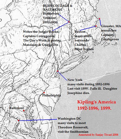
This is a reduced, cropped and version of a physical map of the United States which is in the public domain([1]), and downloaded from the University of Texas website: [2]The map was then annotated by me (Sanjay Tiwari 02:42, 13 October 2006 (UTC)) and is now being released to the public domain. |
|---|---|
| Source |
Originally from en.wikipedia; description page is/was here. |
| Date |
2006-10-13 (original upload date) |
| Author |
Original uploader was Sanjay Tiwari at en.wikipedia |
| Permission (Reusing this image) |
See license section. |
[edit] License information
| I, the copyright holder of this work, hereby release it into the public domain. This applies worldwide. In case this is not legally possible: Afrikaans | Alemannisch | Aragonés | العربية | Asturianu | Български | Català | Česky | Cymraeg | Dansk | Deutsch | Eʋegbe | Ελληνικά | English | Español | Esperanto | Euskara | Estremeñu | فارسی | Français | Galego | 한국어 | हिन्दी | Hrvatski | Ido | Bahasa Indonesia | Íslenska | Italiano | עברית | Kurdî / كوردی | Latina | Lietuvių | Latviešu | Magyar | Македонски | Bahasa Melayu | Nederlands | Norsk (bokmål) | Norsk (nynorsk) | 日本語 | Polski | Português | Ripoarisch | Română | Русский | Shqip | Slovenčina | Slovenščina | Српски / Srpski | Svenska | ไทย | Tagalog | Türkçe | Українська | Tiếng Việt | Walon | 中文(简体) | 中文(繁體) | zh-yue-hant | +/- |
[edit] Original upload log
(All user names refer to en.wikipedia)
- 2006-10-13 02:42 Sanjay Tiwari 501×574×8 (116822 bytes) This is a reduced, cropped and version of a physical map of the United States which is in the public domain([http://www.lib.utexas.edu/maps/faq.html]), and downloaded from the University of Texas website: [http://www.lib.utexas.edu/maps/national_atlas_197
[edit] Licensing
| This image (or other media file) is in the public domain because its copyright has expired. This applies to the United States, Canada, the European Union and those countries with a copyright term of life of the author plus 70 years.
العربية | Asturianu | Български | Català | Česky | Dansk | Deutsch | English | Ελληνικά | Esperanto | Español | Euskara | فارسی | Français | Gaeilge | Galego | עברית | हिन्दी | Bahasa Indonesia | Italiano | 日本語 | 한국어 | Kurdî / كوردی | Lietuvių | Magyar | Nederlands | Norsk (nynorsk) | Македонски | Bahasa Melayu | Polski | Português | Română | Русский | Slovenčina | Slovenščina | Shqip | Suomi | Sámegiella | Türkçe | 中文(简体) | 中文(繁體) | 粵語 | +/- |
Historique du fichier
Cliquer sur une date et une heure pour voir le fichier tel qu’il était à ce moment-là
| Date et heure | Dimensions | Utilisateur | Commentaire | |
|---|---|---|---|---|
| actuel | 18 novembre 2006 à 01:11 | 501×574 (114 Kio) | Chechof | ({{Information |Description=This is a reduced, cropped and version of a physical map of the United States which is in the public domain([http://www.lib.utexas.edu/maps/faq.html]), and downloaded from the University of Texas website: [http://www.lib.utexas.) |
Pages contenant l’image
La page ci-dessous contient cette image :
Métadonnées
Ce fichier contient des informations supplémentaires probablement ajoutées par l’appareil photo numérique ou le numériseur qui l’a acquis. Si le fichier a été modifié depuis son état original, certains détails peuvent ne pas refléter entièrement l’image modifiée.
| Résolution horizontale | 72 dpi |
|---|---|
| Résolution verticale | 72 dpi |
| Logiciel utilisé | Adobe Photoshop 7.0 |
| Date de modification | 31 août 2004 à 13:57 |
| Positionnement YCbCr | 2 |
| Version EXIF | 2.2 |
| Espace colorimétrique | sRGB |


![[2]](http://www.lib.utexas.edu/maps/national_atlas_1970/ca000043.jpg)