Image:Kashmir map.jpg
Un article de Wikipédia, l'encyclopédie libre.
Taille de cet aperçu : 510 × 599 pixels
Image en plus haute résolution (1 029 × 1 209 pixels, taille du fichier : 310 Kio, type MIME : image/jpeg)
| | Ce fichier provient de Wikimedia Commons?. Les informations le concernant sont affichées ci-dessous (procédure). |
[edit] Summary
| Description |
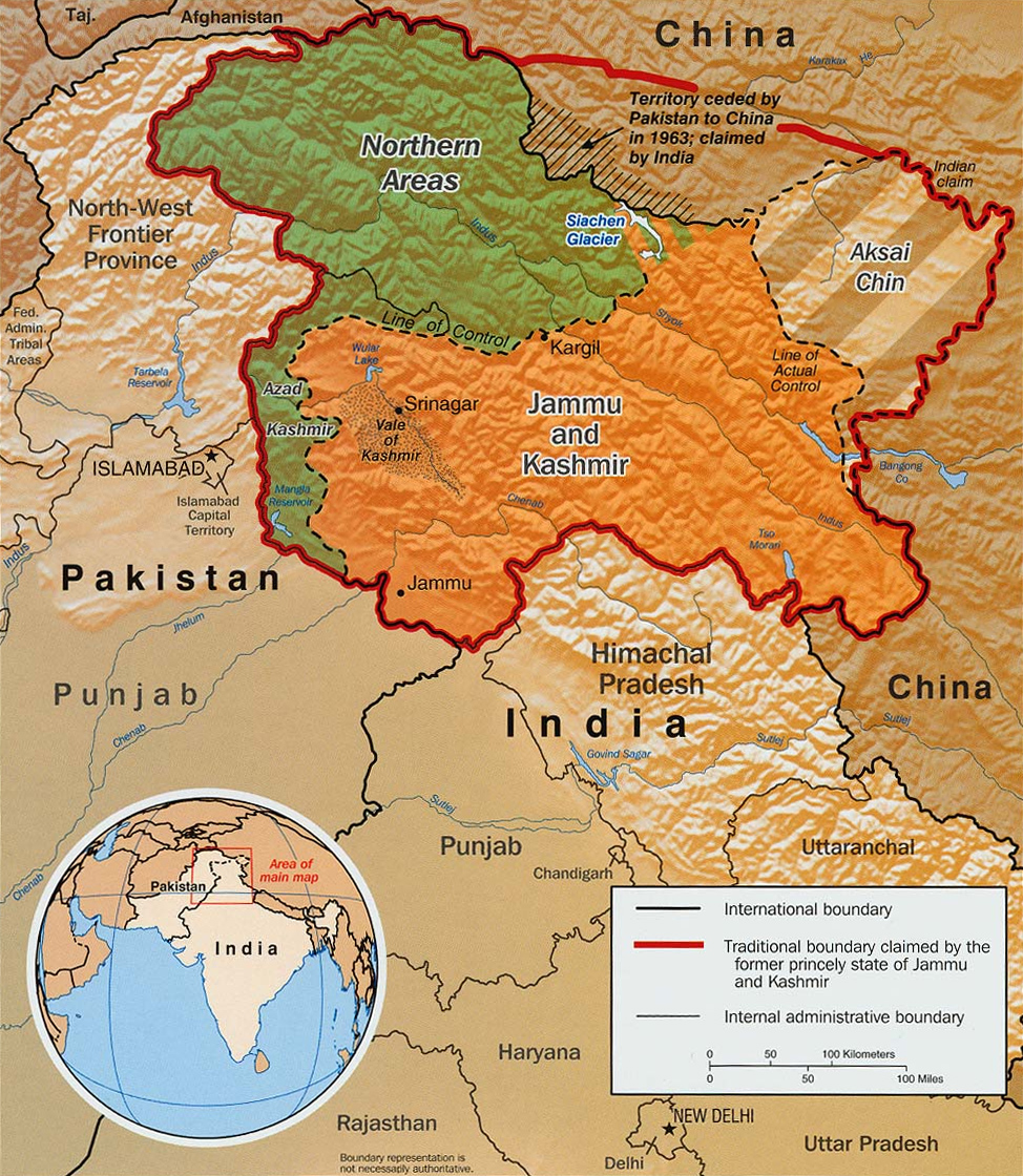
Original text from CIA World Factbook: "The Disputed Territory : Shown in green is Kashmiri region under Pakistani control. The dark-brown region represents Indian-controlled Jammu and Kashmir while the Aksai Chin is under Chinese occupation." Library of Congress, Geography and Map Division, Washington, D.C. 20540-4650 USA. Info from its archive page [1] for this map: Kashmir region. United States. Central Intelligence Agency. CREATED/PUBLISHED [Washington : Central Intelligence Agency, 2003] NOTES "763537AI (R00744) 5-03." Relief shown by shading. Shows boundaries and disputed areas. Includes location map. Scale [ca. 1:510,000]. SUBJECTS
MEDIUM 1 map : col. ; 20 x 17 cm. CALL NUMBER G7653.J3 2003 .U51 REPOSITORY Library of Congress Geography and Map Division Washington, D.C. 20540-4650 USA DIGITAL ID g7653j ct001059 http://hdl.loc.gov/loc.gmd/g7653j.ct001059 |
|||
|---|---|---|---|---|
| Source |
Map is archived here: http://hdl.loc.gov/loc.gmd/g7653j.ct001059 and http://www.lib.utexas.edu/maps/middle_east_and_asia/kashmir_disputed_2003.jpg |
|||
| Date |
2003 |
|||
| Author | ||||
| Permission (Reusing this image) |
|

Historique du fichier
Cliquer sur une date et une heure pour voir le fichier tel qu’il était à ce moment-là
| Date et heure | Dimensions | Utilisateur | Commentaire | |
|---|---|---|---|---|
| actuel | 10 septembre 2007 à 21:55 | 1 029×1 209 (310 Kio) | Timeshifter | (Larger version of the same CIA map. {{PD-USGov-CIA-WF}} ) |
| 13 juin 2005 à 10:08 | 470×565 (72 Kio) | Emuzesto | (From en:. Original text: The Disputed Territory : Shown in green is Kashmiri region under Pakistani control. The dark-brown region represents Indian-controlled Jammu and Kashmir while the Aksai Chin is under Chinese occupati) |
Pages contenant l’image
Les pages ci-dessous contiennent cette image :
Métadonnées
Ce fichier contient des informations supplémentaires probablement ajoutées par l’appareil photo numérique ou le numériseur qui l’a acquis. Si le fichier a été modifié depuis son état original, certains détails peuvent ne pas refléter entièrement l’image modifiée.
| Orientation | Normale |
|---|---|
| Résolution horizontale | 150 dpi |
| Résolution verticale | 150 dpi |
| Logiciel utilisé | Adobe Photoshop 7.0 |
| Date de modification | 4 septembre 2003 à 17:26 |
| Espace colorimétrique | 65535 |

