Image:Jo-map.png
Un article de Wikipédia, l'encyclopédie libre.
Pas de plus haute résolution disponible.
Jo-map.png (328 × 352 pixels, taille du fichier : 18 Kio, type MIME : image/png)
| | Ce fichier provient de Wikimedia Commons?. Les informations le concernant sont affichées ci-dessous (procédure). |
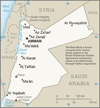
Map of Jordan from CIA World Factbook
| This image is in the public domain because it contains materials that originally came from the United States Central Intelligence Agency's World Factbook.
Deutsch | English | Español | Français | 日本語 | Nederlands | 한국어 | Português | தமிழ் | Magyar | +/- |
 |
- in Esperanto: image:Jordanio.png
- in German: de:Bild:Jordanien.png
- in Arab: image:Jordan sm01.jpg
 |
This map image should be recreated using vector graphics as an SVG file. This has several advantages; see Commons:Media for cleanup for more information. If an SVG form of this image is already available, please upload it. After uploading an SVG, replace this template with template {{Vector version available|new image name.svg}} in this image. |
|
العربية | Български | Català | Česky | Dansk | Deutsch | English | Esperanto | Español | Français | 한국어 | Italiano | Magyar | Lietuvių | Nederlands | 日本語 | Polski | Português | Română | Русский | Suomi | Svenska | Türkçe | Українська | Tiếng Việt | मराठी | 中文(繁體) | 中文(简体) | +/- |
|
Historique du fichier
Cliquer sur une date et une heure pour voir le fichier tel qu’il était à ce moment-là
| Date et heure | Dimensions | Utilisateur | Commentaire | |
|---|---|---|---|---|
| actuel | 21 juin 2007 à 09:27 | 328×352 (18 Kio) | Hoshie | (Updated map of Jordan from the CIA World Factbook, 14 June 07 rev. Src: https://www.cia.gov/library/publications/the-world-factbook/maps/jo-map.gif) |
| 15 avril 2005 à 16:15 | 329×354 (12 Kio) | Oxhop | (Map of Jordan from CIA World Factbook{{PD-USGov-CIA-WF}}Category:Jordan) |
Pages contenant l’image
La page ci-dessous contient cette image :

