Image:IVC Map.png
Un article de Wikipédia, l'encyclopédie libre.
Pas de plus haute résolution disponible.
IVC_Map.png (459 × 400 pixels, taille du fichier : 110 Kio, type MIME : image/png)
| | Ce fichier provient de Wikimedia Commons?. Les informations le concernant sont affichées ci-dessous (procédure). |

see also en:Image:Indus_Map.jpg, Image:CiviltàValleIndoMappa.png, de:Bild:Karte Harappa.png
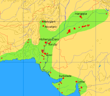
This map is a provisional outline of the Indus Civilization based on online sources. It is the best GFDL map we have so far, but it should be redrawn with greater accuracy and proper source attribution.
The main source of the present map is a scan of some unidentified publication, [1].
Better maps:
Historique du fichier
Cliquer sur une date et une heure pour voir le fichier tel qu’il était à ce moment-là
| Date et heure | Dimensions | Utilisateur | Commentaire | |
|---|---|---|---|---|
| actuel | 6 septembre 2005 à 17:08 | 459×400 (110 Kio) | Dbachmann | (update) |
| 6 septembre 2005 à 13:41 | 450×392 (102 Kio) | Dbachmann | ( by en:User:Dbachmann {{GFDL}} see also en:Image:Indus_Map.jpg, Image:CiviltàValleIndoMappa.png ) |
Pages contenant l’image
La page ci-dessous contient cette image :


![[1]](http://content.answers.com/main/content/wp/en/thumb/d/dd/350px-Indus_Map.jpg)
![[2]](http://www.sp.uconn.edu/~gwang/indusVic.png)