Image:Iroquoiens-St-Laurent.PNG
Un article de Wikipédia, l'encyclopédie libre.
Pas de plus haute résolution disponible.
Iroquoiens-St-Laurent.PNG (336 × 282 pixels, taille du fichier : 23 Kio, type MIME : image/png)
| | Ce fichier provient de Wikimedia Commons?. Les informations le concernant sont affichées ci-dessous (procédure). |
[edit] Summary
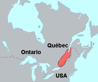
Zone d'occupation approximative des Iroquoiens du Saint-Laurent vers 1535. Approximate area occupied by the St. Lawrence Iroquoians in 1535. (Modifiation of Image:Iroquoian langs.png created by en:User:ish ishwar en 2005).
[edit] References
- Bruce G. Trigger and James F. Pendergast. (1978). "Saint Lawrence Iroquoians", Handbook of North American Indians. Volume 15. Pages 357-361.
- Bruce G. Trigger (ed.). (1978). Handbook of North American Indians. Volume 15. Page ix (map of pre-contact North American Indian languages).
- Marianne Mithun. (1999). The Languages of Native North America. Cambridge: Cambridge University Press. Page 607 (map).
- Moseley and Asher. (1994). Atlas of the World's Languages. Routledge. Map 2.
[edit] Licensing
|
Historique du fichier
Cliquer sur une date et une heure pour voir le fichier tel qu’il était à ce moment-là
| Date et heure | Dimensions | Utilisateur | Commentaire | |
|---|---|---|---|---|
| actuel | 19 août 2006 à 03:46 | 336×282 (23 Kio) | Joseph B | (Nom corrigé. Name corrected.) |
Pages contenant l’image
Les pages ci-dessous contiennent cette image :

