Image:Hurricane Katrina LA landfall radar.gif
Un article de Wikipédia, l'encyclopédie libre.
Pas de plus haute résolution disponible.
Hurricane_Katrina_LA_landfall_radar.gif (772 × 455 pixels, taille du fichier : 6,05 Mio, type MIME : image/gif)
| | Ce fichier provient de Wikimedia Commons?. Les informations le concernant sont affichées ci-dessous (procédure). |
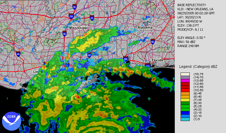
| Description |
Hurricane Katrina making its second landfall in Louisiana, as seen by NWS New Orleans radar. |
|||
|---|---|---|---|---|
| Source |
Animation orginally located on the NCDC August 2005 (direct link). |
|||
| Date |
2005-08-29 |
|||
| Author |
Radar data from NWS New Orleans and processed by the National Climatic Data Center. |
|||
| Permission (Reusing this image) |
|
Historique du fichier
Cliquer sur une date et une heure pour voir le fichier tel qu’il était à ce moment-là
| Date et heure | Dimensions | Utilisateur | Commentaire | |
|---|---|---|---|---|
| actuel | 29 août 2006 à 21:35 | 772×455 (6,05 Mio) | Nilfanion | ({{Information |Description=Hurricane Katrina making its second landfall in Louisiana, as seen by NWS New Orleans radar. |Source=Animation orginally located on the [http://www.ncdc.noaa.gov/oa/climate/research/2005/aug/hazards.html NCDC August 2005] ([http) |
Pages contenant l’image
Les pages ci-dessous contiennent cette image :

